THIS AVALANCHE FORECAST EXPIRED ON December 28, 2020 @ 6:59 am
Avalanche Forecast published on December 27, 2020 @ 6:59 am
Issued by Brandon Schwartz - Tahoe National Forest

Unstable conditions are expected to continue today with a slower than typical post-storm stabilization process. Both persistent slab and wind slab avalanches occurred yesterday and could be triggered again today. Conservative, sub 30 degree slope angle terrain choices are highly recommended for today. Today is not the day to go big. Avalanche danger remains CONSIDERABLE for all elevations.

3. Considerable

?

Above Treeline
Dangerous avalanche conditions. Careful snowpack evaluation, cautious route-finding and conservative decision-making essential.

3. Considerable

?

Near Treeline
Dangerous avalanche conditions. Careful snowpack evaluation, cautious route-finding and conservative decision-making essential.

3. Considerable

?

Below Treeline
Dangerous avalanche conditions. Careful snowpack evaluation, cautious route-finding and conservative decision-making essential.
    Dangerous avalanche conditions. Careful snowpack evaluation, cautious route-finding and conservative decision-making essential.
Avalanche Problem 1: Persistent Slab
  • Type ?
  • Aspect/Elevation ?
  • Likelihood ?
    Certain
    Very Likely
    Likely
    Possible
    Unlikely
  • Size ?
    Historic
    Very Large
    Large
    Small

This avalanche problem is becoming increasingly scary as the problematic weak layers of old faceted (sugary) snow (Dec 11 PWL and Dec 17 weak layer) are buried deeper in the snowpack. The weak layer(s) associated with this avalanche problem have reactivated under the new snow load. One of yesterday's avalanche incidents appears to have been a persistent slab avalanche. This avalanche problem exists on W-NW-N-NE-E aspects, has a widespread distribution in below treeline and near treeline terrain, and isolated distribution above treeline.

Whumpfing, shooting cracks, recent avalanches, and unstable snowpit test results are all indications of unstable snow in the area. Do not write off the significance of any of these clues when dealing with a persistent slab avalanche problem, even if they seem isolated. If you choose not to scale back route choices to less than 30 degree angle slopes only, this is a difficult avalanche problem to manage. Signs of instability may or may not readily present themselves prior to triggering an avalanche. Do not underestimate potential avalanche size, potential runout distance, or the hazard from connected terrain above or to the side. It would be fairly easy to encounter a persistent slab avalanche today while trying to avoid wind slabs. Route find to avoid both.

  Weak layer unverified but the jagged crown suggests a persistent slab avalanche. Skier triggered on the ascent from the red X location on Nipple Pk.

Avalanche Problem 2: Wind Slab
  • Type ?
  • Aspect/Elevation ?
  • Likelihood ?
    Certain
    Very Likely
    Likely
    Possible
    Unlikely
  • Size ?
    Historic
    Very Large
    Large
    Small

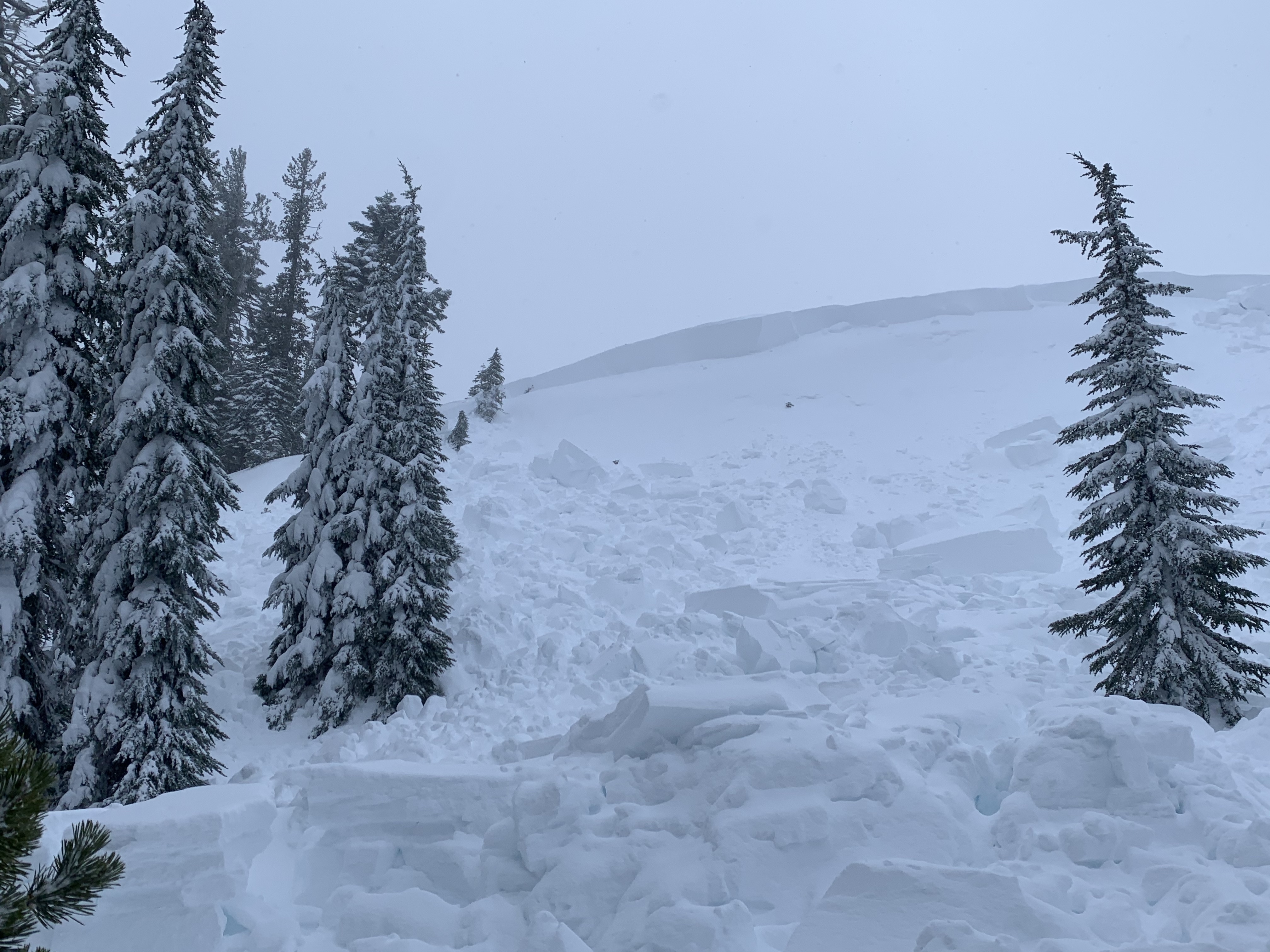
Large amounts of wind drifted snow continue today as problematic wind slabs. The second of yesterday's avalanche incidents was a wind slab that failed under 6 feet of wind drifted snow. This avalanche failed at the old/new snow interface which has the potential for slower than typical stabilization today. This avalanche problem exists on NW-N-NE-E-SE aspects in above treeline and near treeline terrain.

Slopes near ridgetops in the immediate vicinity of cornices and pillows of wind drifted snow are highly suspect. These wind slabs will seem stiff and dense and will likely be difficult to trigger from the edges, potentially not failing until a person is fully out on the slab. Last night's shift to E winds may have scoured these wind slabs slightly, but they are still plenty thick. Identify specific areas of concern and move around them with caution and an avoidance mindset. It would be fairly easy to encounter a wind slab avalanche today while trying to avoid persistent slabs. Route find to avoid both.

     Yesterday's deep wind slab avalanche in the Little Truckee Summit/Independence Lake zone.

recent observations

* Two people were caught in avalanches yesterday, nearly or fully buried without injury. SAC is grateful that no one was injured and greatly appreciates receiving the submitted information to inform this product.

* One avalanche incident was a deep wind slab failing on the old/new snow interface on a NE aspect at around 7,800' in near to above treeline terrain. This was snowmobile triggered in the Little Truckee Summit/Independence Lake zone. Crown depth was around 6 feet.

* The second avalanche incident appears to have been a persistent slab likely failing on the Dec 11 PWL on a NE aspect at around 8,400' in above treeline terrain. This was skier triggered on an ascent of Nipple Peak, south of Carson Pass. Much less is known about this avalanche.

* Yesterday's snowpit data from a variety of locations indicated unstable, problematic results on both the old/new snow interface and deeper in the snowpack on the Dec 11 persistent weak layer.

* Whumpfing was widespread yesterday and reported from numerous locations.

* Long shooting cracks were reported from several areas.

Weather and CURRENT CONDITIONS
weather summary

Storm snow totals from the last 36 hours range from 9 to 14 inches with 1 to 1.75 inches of SWE. Ridgetop winds shifted from SW to E yesterday evening. Cloud cover is forecast for today ahead of another approaching weather system. Light snowfall could start this afternoon, but is mainly expected tonight. New snow amounts of 2 to 5 inches are expected over the next 36 hours, with the greatest amounts over the southern half of the forecast area. A strong NE ridgetop wind event is forecast for Monday night.

CONDITIONS ALONG THE SIERRA CREST BETWEEN 8200 FT. AND 9200 FT. IN THE LAST 24 HOURS
6am temperature: 18 to 24 deg. F.
Max. temperature: 23 to 27 deg. F.
Average ridgetop wind direction: SW shifting to E
Average ridgetop wind speed: SW 40 mph | E 20 mph
Maximum ridgetop wind gust: SW 100 mph | E 37 mph
New snowfall: 1 to 3 inches
Total snow depth: 25 to 37 inches
Two-Day Mountain Weather Forecast Produced in partnership with the Reno NWS
For 7000 ft. to 8000 ft.
Sunday Sunday Night Monday
Weather: Cloudy. Slight chance of snow in the afternoon. Snow levels below 7000 feet. Chance of precipitation is 15%. Cloudy. Snow likely, especially south of Lake Tahoe. Snow levels below 7000 feet. Chance of precipitation is 55%. Cloudy. Snow likely mainly south of Lake Tahoe. Snow levels below 7000 feet. Chance of precipitation is 55%.
Temperatures: 27 to 32. deg. F. 16 to 22. deg. F. 24 to 29. deg. F.
Mid Slope Winds: Light winds. Light winds. Light winds.
Expected snowfall: Little or no accumulation. | SWE = trace amounts. 80% probability up to 2 inches. 20% probability of 2 to 4 inches. | SWE = less than 0.10 inch. 60% probability of 1 to 3 inches. 40% probability up to 1 inch. | SWE = up to 0.15 inch.
For 8000 ft. to 9000 ft.
Sunday Sunday Night Monday
Weather: Cloudy. Slight chance of snow in the afternoon. Snow levels below 7000 feet. Chance of precipitation is 20%. Cloudy. Snow likely, especially south of Lake Tahoe. Snow levels below 7000 feet. Chance of precipitation is 55%. Cloudy. Snow likely mainly south of Lake Tahoe. Snow levels below 7000 feet. Chance of precipitation is 60%.
Temperatures: 23 to 28. deg. F. 14 to 19. deg. F. 20 to 25. deg. F.
Ridge Top Winds: Southeast 15 to 20 mph with gusts to 30 mph. East around 15 mph with gusts to 30 mph. Northeast around 15 mph with gusts to 25 mph in the morning becoming light.
Expected snowfall: Little or no accumulation. | SWE = trace amounts. 70% probability up to 2 inches. 30% probability of 2 to 4 inches. | SWE = up to 0.15 inch. 60% probability of 1 to 3 inches. 40% probability up to 1 inch. | SWE = up to 0.20 inch.
Disclaimer

This avalanche forecast is provided through a partnership between the Tahoe National Forest and the Sierra Avalanche Center. This forecast covers the Central Sierra Nevada Mountains between Yuba Pass on the north and Ebbetts Pass on the south. Click here for a map of the forecast area. This forecast applies only to backcountry areas outside established ski area boundaries. This forecast describes general avalanche conditions and local variations always occur. This forecast expires 24 hours after the posted time unless otherwise noted. The information in this forecast is provided by the USDA Forest Service who is solely responsible for its content.

For a recorded version of the avalanche forecast call (530) 587-3558 x258