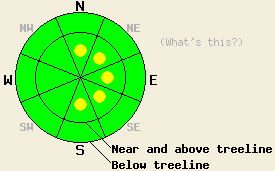
This Avalanche Advisory was published on January 2, 2010:

|
January 2, 2010 at 8:00 am |
|
Near and above treeline, isolated pockets of MODERATE avalanche danger exist on wind-loaded N-NE-E aspects, 35 degrees and steeper. By this afternoon small, isolated pockets of MODERATE danger should start to form on NE-E-SE-S aspects steeper than 35 degrees due to a shift in the wind direction. Avalanche danger in other areas will drop to LOW meaning that avalanche activity will be unlikely but not impossible. |
|
|
|
Forecast Discussion:
Above 7500' yesterday 2-3 inches of new snow fell across the forecast area. Below 7500' yesterday's precipitation was a mix of rain and snow. The strong southwest winds have continued to transport snow through the night. In some areas the winds have started to decrease and shift to the northwest due to a high pressure ridge moving into the forecast area. This ridge should cause the winds to shift more to the northwest today and to the northeast and east by tomorrow. The winds should also decrease over the next 24 hours dropping to around 10 mph by tomorrow afternoon. The high-pressure ridge should also bring clearer skies and warmer temperatures to the forecast area over the next few days.
We did not receive any new reports of avalanche activity yesterday. Observations from Waterhouse Peak showed that the southwest winds continued to transport snow throughout the day. Plenty of unconsolidated snow remains for transport on the NW-N-NE-E aspects today. The snow that has fallen since 12/30 has bonded to the older snow surfaces in this area. Snowpit tests and observations also showed that a layer of weak sugary crystals still exists near the base of the snowpack (Oct 19th facet layer). This layer has started to gain some strength in this area, but fractures can still propagate through the snowpack along this layer if it does break (video). On Waterhouse yesterday's precipitation was mostly snow; however in areas below 7500' precipitation was a mix of rain and snow and should leave a rain crust on the snow surface on all aspects below 7500'.
Avalanche concern #1:
Wind-slabs that formed during the last few days and new wind-slabs that form today as the winds shift will comprise the primary avalanche concern. The strong southwest winds added more snow to the recently formed wind-slabs on N-NE-E aspects over the last 24 hours. These wind-slabs have bonded well to the snow below them in most places; however, isolated pockets of human-triggerable wind-slabs will continue to exist today near and above treeline on heavily wind-loaded N-NE-E aspects steeper than 35 degrees. As the winds shift to the northwest toady these wind-slabs will move onto the E-SE-S aspects. Most of the wind-slabs that form on these aspects today should remain small; however, some of them could grow large enough to bury a person on the most heavily wind-loaded aspects by this afternoon depending on the strength of the northwest wind. Human-triggering of the wind slabs that form today will be possible on the most heavily wind-loaded slopes.
Avalanche concern #2:
Deep slab instability involving the Oct 19 facet layer near the base of the snowpack is unlikely but not impossible in a few isolated areas below treeline on sheltered NW-N-NE aspects above 7,700'. Very strong snow in the middle and upper portions of the snowpack has kept this layer from failing in areas where it remains weak. Human triggering of this weak layer remains an unlikely event and is becoming more unlikely over time.
The bottom line:
Near and above treeline, isolated pockets of MODERATE avalanche danger exist on wind-loaded N-NE-E aspects, 35 degrees and steeper. By this afternoon small, isolated pockets of MODERATE danger should start to form on NE-E-SE-S aspects steeper than 35 degrees due to a shift in the wind direction. Avalanche danger in other areas will drop to LOW meaning that avalanche activity will be unlikely but not impossible.
Weather Observations from along the Sierra Crest between 8200 ft and 8800 ft:
| 0600 temperature: | 25 deg. F. |
| Max. temperature in the last 24 hours: | 31 deg. F. |
| Average wind direction during the last 24 hours: | West shifting to the northwest around 1 am in some locations. |
| Average wind speed during the last 24 hours: | 30-40 mph |
| Maximum wind gust in the last 24 hours: | 77 mph |
| New snowfall in the last 24 hours: | 2-3 inches |
| Total snow depth: | 38-67 inches |
Two-Day Mountain Weather Forecast - Produced in partnership with the Reno NWS
For 7000-8000 ft: |
|||
| Saturday: | Saturday Night: | Sunday: | |
| Weather: | Partly cloudy in the morning becoming mostly cloudy in the afternoon | Partly cloudy | Partly cloudy |
| Temperatures: | 38-43 deg. F. | 28-34 deg. F. | 40-45 deg. F. |
| Wind direction: | Northwest | East | East becoming variable in the afternoon |
| Wind speed: | 10-15 mph | 10 mph | 5-10 mph |
| Expected snowfall: | O in. | O in. | O in. |
For 8000-9000 ft: |
|||
| Saturday: | Saturday Night: | Sunday: | |
| Weather: | Partly cloudy in the morning becoming mostly cloudy in the afternoon | Partly cloudy | Partly cloudy |
| Temperatures: | 35-40 deg. F. | 27-33 deg. F. | 37-42 deg. F. |
| Wind direction: | Northwest | Northwest shifting to the north after midnight | Northeast shifting to the northwest in the afternoon |
| Wind speed: | 10-20 mph with gusts to 35 mph | 10-15 mph with gusts to 25 mph decreasing to 10 mph after midnight | 10-20 mph with gusts to 30 mph decreasing to 10 mph in the afternoon |
| Expected snowfall: | O in. | O in. | O in. |


