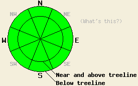
This Avalanche Advisory was published on January 3, 2010:

|
January 3, 2010 at 8:00 am |
|
LOW avalanche danger exists on all aspects and at all elevations. Avalanche activity will be unlikely but not impossible. Use normal caution when traveling in the backcountry. |
|
|
|
Forecast Discussion:
A high pressure ridge over the forecast area should keep the weather clear and dry. Winds should remain light out of the north and east today. They should shift to the south and west tomorrow afternoon in response to a small, dry and weak low pressure. This low pressure should also bring a few more clouds to the region tomorrow afternoon and evening.
Yesterday, the weather remained clear and calm. Most remote sensors reported wind speeds between 0 mph and 5 mph during the day. Observers reported no snow transport or new wind-slab formation. Observations and snowpit data from Angora Peak (north of Echo Summit) and Elephant's Back (Carson Pass) showed a mostly stable snowpack. Bonds within the recent snow and between recent snow and the older snow continue to gain strength. The layer of weak, sugary snow near the bottom of the snowpack continues to consolidate. These previously sharp, angular facets have started to round (a stronger shape). Compare these two photos to see how they have changed: photo 1, taken on Dec. 26th - large, weak, angular facets; photo 2, taken Jan. 2nd - facets that have started to round and are getting stronger. Stability tests on this weak layer also indicate that failure of this layer due to human-triggering continues to grow more and more unlikely. Propagation tests have started to show that even if this layer does break fractures propagating through the snowpack along this layer have become less likely as well. Observations on Incline Lake Peak and on Angora Peak above 7500' showed unconsolidated snow remains on the sheltered N-NE aspects. Below 7500' a breakable rain-crust existed as the snow surface on Angora Peak.
Avalanche concerns:
The calm, mild, dry weather and the passage of time have allowed the recent snow and recently formed wind-slabs to consolidate and bond to the older snow surfaces. Failure within the recent snow or of these wind-slabs remains unlikely. However, some of the cornices perched above the wind-loaded slopes may still break in response to a person's weight. The same weather, a deeper snowpack, and more time have also allowed the persistent weak layer of facets that has been lurking at the bottom of the snowpack since Oct. to gain enough strength to support the snowpack above it. A strong consolidated layer of snow above this layer also protects it from feeling any of the forces that people place on the snow surface. This protective layer combined with the facets' new-found strength make deep-slab avalanche activity resulting from failure of this layer unlikely today. Even though avalanche activity will be unlikely today, it is not impossible. Please continue to use safe travel techniques and normal caution when traveling in the backcountry.
The bottom line:
LOW avalanche danger exists on all aspects and at all elevations. Avalanche activity will be unlikely but not impossible. Use normal caution when traveling in the backcountry.
Weather Observations from along the Sierra Crest between 8200 ft and 8800 ft:
| 0600 temperature: | 28 deg. F. |
| Max. temperature in the last 24 hours: | 35 deg. F. |
| Average wind direction during the last 24 hours: | Northeast |
| Average wind speed during the last 24 hours: | 0-14 mph |
| Maximum wind gust in the last 24 hours: | 30 mph |
| New snowfall in the last 24 hours: | O inches |
| Total snow depth: | 36-65 inches |
Two-Day Mountain Weather Forecast - Produced in partnership with the Reno NWS
For 7000-8000 ft: |
|||
| Sunday: | Sunday Night: | Monday: | |
| Weather: | Partly cloudy | Partly cloudy | Partly cloudy in the morning becoming mostly cloudy in the afternoon. |
| Temperatures: | 39-44 deg. F. | 27-33 deg. F. | 38-43 deg. F. |
| Wind direction: | Northeast shifting to the southeast in the afternoon | Southeast | Southeast in the morning becoming variable in the afternoon |
| Wind speed: | 5-15 mph decreasing to 10 mph | up to 10 mph | 10 mph |
| Expected snowfall: | O in. | O in. | O in. |
For 8000-9000 ft: |
|||
| Sunday: | Sunday Night: | Monday: | |
| Weather: | Partly cloudy | Partly cloudy | Partly cloudy in the morning becoming mostly cloudy in the afternoon. |
| Temperatures: | 36-41 deg. F. | 25-33 deg. F. | 36-41 deg. F. |
| Wind direction: | Northeast shifting to the southeast in the afternoon | Southeast | South shifting to the west in the afternoon |
| Wind speed: | 10-20 mph with gusts to 35 mph decreasing to 5-15 mph in the afternoon | 5-15 mph | 10 mph with gusts to 25 mph |
| Expected snowfall: | O in. | O in. | O in. |


