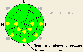
This Avalanche Advisory was published on March 17, 2010:

|
March 17, 2010 at 6:53 am |
|
Early this morning, avalanche danger is LOW for all elevations and aspects. Pockets of MODERATE avalanche danger will form at all elevations on E-SE-S-SW-W aspects 37 degrees and steeper in response to daytime warming. |
|
|
|
Forecast Discussion:
A weather system passing well to the north of the forecast area will bring a small amount of moisture to the region this afternoon. Warm air temperatures will combine with this moisture to create isolated areas of thunderstorms this afternoon and evening. Snow level this afternoon is expected around 8,000' to 8,500'. Air temperatures remained above freezing overnight in most locations with air temperatures above 7,000' in the mid 30s to low 40s this morning. Ridgetop winds have decreased and shifted from moderate speed southwest winds yesterday to light east winds overnight.
Observations made yesterday along the Sierra Crest between 7,200' and 8,800' while touring along the rim of Cold Stream Canyon (Donner Summit area) and the rim of Deep Creek and Pole Creek drainages revealed that a solid refreeze had occurred overnight. Cold wind pressed snow remained on N aspects above 8,000' with melt freeze conditions on all E-SE-S-SW-W aspects. Areas of wet surface snow began to form on S aspects at 8,800' by 10:30 am. Large skier triggered roller balls up to 2 feet in diameter occurred below treeline at 8,000' on a sun exposed E aspect 38 degree slope at 1:30 pm. By 2 pm, 4 to 6 inches of wet surface snow existed on all E-SE-S-SW-W aspects below 8,400' with around 1 inch of wet surface snow on northerly aspects below 8,000'. Below 6,800', full drainage of the snowpack was noted on S aspects where the snowpack was less then 3 feet deep and existed over granite slabs.
Warm air temperatures overnight are expected to have allowed for a weaker snow surface refreeze last night. This is supported by reports this morning from ski area grooming operations.
Avalanche concerns: Warming instability
Mostly cloudy skies for much of today will limit the amount of incoming solar radiation, but warm air temperatures and a weaker snow surface refreeze last night will allow for pockets of wet snow instability to form again today. These pockets of instability will occur mainly on E-SE-S-SW-W aspects below 9,000'. Very isolated areas of instability are possible on lower elevation NW-N-NE aspects as well. Areas of instability that form today are expected to occur as loose snow avalanches involving the top few inches of wet surface snow. Deep wet slab instability remains unlikely at this time.
The bottom line:
Early this morning, avalanche danger is LOW for all elevations and aspects. Pockets of MODERATE avalanche danger will form at all elevations on E-SE-S-SW-W aspects 37 degrees and steeper in response to daytime warming.
Weather Observations from along the Sierra Crest between 8200 ft and 8800 ft:
| 0600 temperature: | 35 to 40 deg. F. |
| Max. temperature in the last 24 hours: | 45 to 51 deg. F. |
| Average wind direction during the last 24 hours: | Southwest shifting to east |
| Average wind speed during the last 24 hours: | 17 mph |
| Maximum wind gust in the last 24 hours: | 51 mph |
| New snowfall in the last 24 hours: | O inches |
| Total snow depth: | 88 to 126 inches |
Two-Day Mountain Weather Forecast - Produced in partnership with the Reno NWS
For 7000-8000 ft: |
|||
| Wednesday: | Wednesday Night: | Thursday: | |
| Weather: | Mostly cloudy skies with scattered rain showers and isolated thunderstorms in the afternoon. | Mostly cloudy skies with isolated rain showers and thunderstorms in the early evening. Partly cloudy skies after midnight. | Partly cloudy skies with isolated showers in the morning. Scattered showers and isolated thunderstorms in the afternoon. Snow level 7,500ft in the morning lowering to 7,000ft in the afternoon. |
| Temperatures: | 50 to 55 deg. F. | 32 to 37 deg. F. | 40 to 45 deg. F. in the morning. Falling to 30 to 37 deg. F. |
| Wind direction: | E becoming variable | Variable | Variable becoming NE in the afternooon. |
| Wind speed: | Up to 10 mph. | Less than 10 mph. | Up to 10 mph in the morning increasing to 10 to 20 mph in the afternoon. |
| Expected snowfall: | O in. | O in. | 0 to trace in. |
For 8000-9000 ft: |
|||
| Wednesday: | Wednesday Night: | Thursday: | |
| Weather: | Mostly cloudy skies with scattered showers and isolated thunderstorms in the afternoon. Snow level 8,000ft to 8,500ft. | Mostly cloudy skies with isolated showers and thunderstorms in the early evening. Partly cloudy skies after midnight. Snow level near 8,000ft. | Partly cloudy skies with isolated snow showers in the morning. Scattered snow showers and isolated thunderstorms in the afternoon. |
| Temperatures: | 45 to 50 deg. F. | 30 to 36 deg. F. | 31 to 41 deg. F. in the morning. Falling to 25 to 32 deg. F. |
| Wind direction: | E becoming variable | Variable | N shifting to NE |
| Wind speed: | 5 to 15 mph. | Up to 10 mph. | Up to 10 mph in the morning increasing to 25 to 35 mph with gusts to 50 mph in the afternoon. |
| Expected snowfall: | 0 to trace in. | 0 to trace in. | 0 to trace in. |


