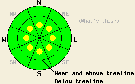
This Avalanche Advisory was published on February 10, 2013:

|
February 10, 2013 at 8:00 am |
|
In most areas the avalanche danger is LOW. On a few isolated slopes steeper than 35 degrees, small pockets of MODERATE avalanche danger may remain on near and above treeline aspects along the Sierra Crest due wind slabs resting on frozen crusts. Small loose snow avalanches may also be possible on some steep slopes at all elevations today due unconsolidated snow resting on those frozen crusts. |
|
|
|
Forecast Discussion:
The high pressure ridge building over the forecast area should keep skies mostly clear today. Cold air and northerly flow left over from the recent cold front should also persist across the forecast area. The forecast calls for daytime highs in the teens and 20's today. Tomorrow high temperatures should start climbing as the northerly flow begins to decrease. The northeast winds did increase some last night. The forecast calls for them to continue increasing today. By tonight they should reach their peak before they start decreasing tomorrow.
Observations from the last few days have shown highly variable amounts of snow above the frozen crusts. The recent snow depths above the crusts on sheltered slopes measured about 1 inch in the Mt. Rose area, 3-5 inches in the Donner Summit area, about 4 inches on Carson Pass yesterday, and 6-8 inches on Rubicon Peak yesterday. On more wind exposed slopes a mix of scoured crusts, soft wind slabs, and soft snow exists. Below this new snow the frozen crusts remain supportable in some areas and have become breakable in other areas. Snowpit data from Rubicon Peak (snowpit, more info) and the Frog Lake area near Carson Pass (snowpit, photo, more info) both showed that the snow around the rain crusts continues to weaken on the northerly aspects. Tests on this layer showed that it can easily break, but the resulting fractures do not travel very far. Data and observations also showed the the snow above this layer remains unconsolidated and has not formed a slab layer in most areas. In the most heavily wind loaded areas some wind slabs do exist. Yesterday the winds remained calm. No snow transport was observed from Rubicon Peak or Carson Pass yesterday.
Avalanche Concern #1: Wind Slabs
Small wind slabs that extend short distances downslope still exist on some leeward aspects. Most of these small slabs do not hold enough snow to bury a person. In the most heavily wind loaded areas that received the most new snow, some isolated larger wind slabs may exist. These slabs reside on top of firm crusts with weak snow around them. Human triggering of these wind slabs will remain possible today. The largest and most fragile of these small wind slabs will exist on the most heavily wind loaded NW-N-NE-E-SE aspects along the Sierra Crest in areas that received the highest snowfall amounts. Some smaller wind slabs may have formed on the W-SW-S-SE aspects due to last night's increased northeast winds. If the northeast winds continue to increase as forecasted today, these wind slabs could become more widespread.
Avalanche Problem #2: Loose Snow Avalanches:
Soft, unconsolidated snow resting on top of a smooth slippery surface will allow small loose snow sluffs to remain possible on steep slopes today. This loose snow problem should remain shallow and surficial and not involve enough snow to bury a person. In areas that received the most new snow, a few of these sluffs could change one's course of travel and push one into areas with other consequences.
The bottom line:
In most areas the avalanche danger is LOW. On a few isolated slopes steeper than 35 degrees, small pockets of MODERATE avalanche danger may remain on near and above treeline aspects along the Sierra Crest due wind slabs resting on frozen crusts. Small loose snow avalanches may also be possible on some steep slopes at all elevations today due unconsolidated snow resting on those frozen crusts.
Weather Observations from along the Sierra Crest between 8200 ft and 8800 ft:
| 0600 temperature: | 14-19 deg. F. |
| Max. temperature in the last 24 hours: | 18-28 deg. F. |
| Average wind direction during the last 24 hours: | North and northeast |
| Average wind speed during the last 24 hours: | 10-20 mph with some areas reporting 25-35 mph |
| Maximum wind gust in the last 24 hours: | 34-59 mph |
| New snowfall in the last 24 hours: | O inches |
| Total snow depth: | 57-81 inches |
Two-Day Mountain Weather Forecast - Produced in partnership with the Reno NWS
For 7000-8000 ft: |
|||
| Sunday: | Sunday Night: | Monday: | |
| Weather: | Mostly sunny | Clear | Sunny |
| Temperatures: | 21-28 deg. F. | 10-18 deg. F. | 26-33 deg. F. |
| Wind direction: | Northeast | Northeast | Northeast |
| Wind speed: | 20-30 mph with gusts to 45 mph | 30-40 mph with gusts to 50 mph | 30-40 mph with gusts to 50 mph decreasing to 15-25 mph with gusts to 35 mph in the afternoon |
| Expected snowfall: | O in. | O in. | O in. |
For 8000-9000 ft: |
|||
| Sunday: | Sunday Night: | Monday: | |
| Weather: | Mostly sunny | Clear | Sunny |
| Temperatures: | 14-21 deg. F. | 11-17 deg. F. | 21-28 deg. F. |
| Wind direction: | Northeast | Northeast | Northeast |
| Wind speed: | 25-35 mph with gusts to 55 mph | 35-45 mph with gusts to 70 mph | 35-45 mph with gusts to 65 mph decreasing to 20-30 mph with gusts to 50 mph in the afternoon |
| Expected snowfall: | O in. | O in. | O in. |


