THIS AVALANCHE FORECAST EXPIRED ON February 18, 2014 @ 7:03 am
Avalanche Forecast published on February 17, 2014 @ 7:03 am
Issued by Andy Anderson - Tahoe National Forest - Sierra Avalanche Center

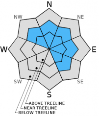
Near and above treeline pockets of MODERATE avalanche danger still exist on wind loaded slopes 35 degrees and steeper on NW-N-NE-E-SE aspects due to lingering wind slabs. In wind protected areas below treeline and in wind scoured areas near and above treeline, avalanche danger remains LOW.

2. Moderate

?

Above Treeline
Heightened avalanche conditions on specific terrain features. Evaluate snow and terrain carefully; identify features of concern.

2. Moderate

?

Near Treeline
Heightened avalanche conditions on specific terrain features. Evaluate snow and terrain carefully; identify features of concern.

1. Low

?

Below Treeline
Generally safe avalanche conditions. Watch for unstable snow on isolated terrain features.
    Heightened avalanche conditions on specific terrain features. Evaluate snow and terrain carefully; identify features of concern.
Avalanche Problem 1: Wind Slab
  • Type ?
  • Aspect/Elevation ?
  • Likelihood ?
    Certain
    Very Likely
    Likely
    Possible
    Unlikely
  • Size ?
    Historic
    Very Large
    Large
    Small

Wind slabs still exist on on the leeward NW-N-NE-E-SE aspects. In many places these wind slabs remain relatively small. Increasing bond strength between the wind slabs and the old snow below them should make triggering these slabs more difficult today in most places. However, human triggered avalanches resulting from the failure of these wind slabs will remain possible in the most heavily wind loaded areas that received the most snow on Saturday night. Wind slabs 1-2 ft in depth could exist in those areas. Complex and/or extreme terrain including "cliffy" areas, unsupported slopes, couliors, etc represent the most likely places to find these pockets of larger more fragile wind slabs, but they could linger on other near and above treeline wind-loaded N-NE-E aspects or cross-loaded NW and SE aspects as well.

recent observations

A skier triggered an avalanche on a N-NE aspect at about 9600 ft. on Red Lake Peak yesterday. The reporting party saw it from a distance and could not ascertain specific details concerning this slide. It did occur in complex, steep terrain that commonly experiences wind loading and looked to be about 100 ft wide. As more details come in we will post them in the observations section. 

Farther north on Castle Peak wind slabs up to 16 inches in depth did exist on the most heavily wind loaded NW-N-NE aspects. Ski cuts on wind loaded test slopes, snowpit tests, and general observations in this area showed that good bonding seemed to exist between the wind slabs and the rain crusts below. In the Castle Peak area the snowpack below the thick, strong, and now very supportable rain crust consists of wet snow that continues to consolidate. 

Weather and CURRENT CONDITIONS
weather summary

A small high pressure ridge over the region should keep the weather dry and mostly clear through tomorrow. The forecast calls for continued southwest winds that should increase in strength this afternoon before calming some overnight. Expect slightly warmer than normal daytime highs through Tuesday as well. By tomorrow afternoon cloud cover and the southwest winds should both increase again as a small dry cold front approaches the region. 

CONDITIONS ALONG THE SIERRA CREST BETWEEN 8200 FT. AND 9200 FT. IN THE LAST 24 HOURS
6am temperature: 25 to 35 deg. F.
Max. temperature: 32 to 42 deg. F.
Average ridgetop wind direction: Southwest
Average ridgetop wind speed: 25 to 30 mph
Maximum ridgetop wind gust: 55 mph
New snowfall: 0 to 1 inches
Total snow depth: 38 to 50 inches
Two-Day Mountain Weather Forecast Produced in partnership with the Reno NWS
For 7000 ft. to 8000 ft.
Monday Monday Night Tuesday
Weather: Mostly sunny with some scattered high clouds Partly cloudy Mostly cloudy
Temperatures: 39 to 45 deg. F. 25 to 30 deg. F. 41 to 47 deg. F.
Mid Slope Winds: Southwest Southwest Southwest
Wind Speed: 10 to 20 mph with gusts to 30 mph increasing to 20 to 30 mph with gusts to 40 mph in the afternoon 10 to 20 mph with gusts to 30 mph 10 to 20 mph with gusts to 30 mph in the afternoon
Expected snowfall: 0 0 0
For 8000 ft. to 9000 ft.
Monday Monday Night Tuesday
Weather: Mostly sunny with some scattered high clouds Partly cloudy Mostly cloudy
Temperatures: 33 to 39 deg. F. 25 to 30 deg. F. 36 to 41 deg. F.
Ridge Top Winds: Southwest Southwest Southwest
Wind Speed: 20 to 30 mph with gusts to 45 mph increasing to 30 to 45 mph with gusts to 65 mph in the afternoon 20 to 30 mph with gusts to 45 mph 15 to 20 mph with gusts to 30 mph increasing to 25 to 30 mph with gusts to 40 mph in the afternoon
Expected snowfall: 0 0 0
Disclaimer

This avalanche advisory is provided through a partnership between the Tahoe National Forest and the Sierra Avalanche Center. This advisory covers the Central Sierra Nevada Mountains between Yuba Pass on the north and Ebbetts Pass on the south. Click here for a map of the forecast area. This advisory applies only to backcountry areas outside established ski area boundaries. This advisory describes general avalanche conditions and local variations always occur. This advisory expires 24 hours after the posted time unless otherwise noted. The information in this advisory is provided by the USDA Forest Service who is solely responsible for its content.