THIS AVALANCHE FORECAST EXPIRED ON January 23, 2015 @ 6:50 am
Avalanche Forecast published on January 22, 2015 @ 6:50 am
Issued by Andy Anderson - Tahoe National Forest - Sierra Avalanche Center

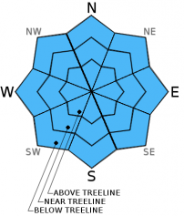
The avalanche danger remains LOW for all elevations and aspects. Other hazards including icy conditions and a shallow snowpack with lots of obstacles remain. Continue to practice safe travel habits and thoughtful decision making when traveling in the backcountry.

1. Low

?

Above Treeline
Generally safe avalanche conditions. Watch for unstable snow on isolated terrain features.

1. Low

?

Near Treeline
Generally safe avalanche conditions. Watch for unstable snow on isolated terrain features.

1. Low

?

Below Treeline
Generally safe avalanche conditions. Watch for unstable snow on isolated terrain features.
    Generally safe avalanche conditions. Watch for unstable snow on isolated terrain features.
Avalanche Problem 1: Normal Caution
  • Type ?
  • Aspect/Elevation ?
  • Likelihood ?
    Certain
    Very Likely
    Likely
    Possible
    Unlikely
  • Size ?
    Historic
    Very Large
    Large
    Small

Last night the snowpack should have refrozen well before the cloud cover and warmer temperatures moved in after midnight. This strong refreeze, today's widespread cloud cover, continued light winds, and a snowpack with well established drainage channels should prevent any significant wet snow instabilities from forming today. Since sunshine represents the best way to warm, melt, and soften the frozen snow surface, the cooling factors mentioned above especially the cloud cover may also prevent much soft snow from forming today even though temperatures should climb above freezing. If the cloud cover does not become as widespread as forecasted and if some SE-S-SW aspects do receive direct sun today, they may soften for a short time. Otherwise they may remain mostly frozen all day. All other aspects should also remain mostly frozen today.

While avalanche activity will remain unlikely today, other hazards including icy conditions that could allow for long uncontrollable falls and a shallow snowpack with lots of obstacles to hit remain.

recent observations

Yesterday on Red Lake Peak, the SE-S-SW aspects that received direct sunshine did soften during a short window of time (between 11:30 am and 12:30 pm) before they started to refreeze again. Observations did not reveal any signs of wet snow instabilities. All other aspects in this area remained icy, firm, and frozen all day long. On the northerly aspects, snowpit data indicated that softer snow layers do still exist around the upper rain crusts. Tests on these layers showed that they continue to strengthen and form bonds within themselves and with the layers around them.

Weather and CURRENT CONDITIONS
weather summary

Cloud cover started to build over the area after midnight last night and caused temperatures to start warming up. Overnight lows did get below freezing before the cloud cover moved in. This cloud cover should become more widespread today as a small low pressure moves across the region. Light southwest and west winds should accompany these clouds. This system should move out of the area later today, and skies should begin to clear as a high pressure starts to push into the region. The forecast calls for a mostly clear night followed by a sunny and warmer day tomorrow. The winds should shift to the northeast and increase some tonight and tomorrow.

CONDITIONS ALONG THE SIERRA CREST BETWEEN 8200 FT. AND 9200 FT. IN THE LAST 24 HOURS
6am temperature: 28 to 38 deg. F.
Max. temperature: 39 to 41 deg. F.
Average ridgetop wind direction: East shifting to the southwest after midnight
Average ridgetop wind speed: 20 mph
Maximum ridgetop wind gust: 40 mph
New snowfall: 0 inches
Total snow depth: 23 to 33 inches
Two-Day Mountain Weather Forecast Produced in partnership with the Reno NWS
For 7000 ft. to 8000 ft.
Thursday Thursday Night Friday
Weather: Mostly cloudy Partly cloudy in the evening becoming clear overnight Sunny
Temperatures: 37 to 44 deg. F. 22 to 28 deg. F. 39 to 46 deg. F.
Mid Slope Winds: Variable Northeast Northeast
Wind Speed: Light Light becoming 10 to 15 mph after midnight 15 to 20 mph with gusts to 30 mph
Expected snowfall: 0 0 0
For 8000 ft. to 9000 ft.
Thursday Thursday Night Friday
Weather: Mostly cloudy Partly cloudy in the evening becoming clear overnight Sunny
Temperatures: 34 to 40 deg. F. 19 to 26 deg. F. 36 to 43 deg. F.
Ridge Top Winds: West West shifting to the northeast after midnight Northeast
Wind Speed: Light increasing to 10 to 15 mph with gusts to 25 mph in the afternoon 10 to 15 mph with gusts to 30 mph 20 to 30 mph with gusts to 35 mph increasing to gusts to 45 mph in the afternoon
Expected snowfall: 0 0 0
Disclaimer

This avalanche advisory is provided through a partnership between the Tahoe National Forest and the Sierra Avalanche Center. This advisory covers the Central Sierra Nevada Mountains between Yuba Pass on the north and Ebbetts Pass on the south. Click here for a map of the forecast area. This advisory applies only to backcountry areas outside established ski area boundaries. This advisory describes general avalanche conditions and local variations always occur. This advisory expires 24 hours after the posted time unless otherwise noted. The information in this advisory is provided by the USDA Forest Service who is solely responsible for its content.