THIS AVALANCHE FORECAST EXPIRED ON January 24, 2015 @ 6:23 am
Avalanche Forecast published on January 23, 2015 @ 6:23 am
Issued by Andy Anderson - Tahoe National Forest - Sierra Avalanche Center

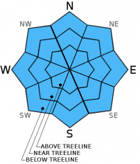
The avalanche danger remains LOW for all elevations and aspects. Other hazards including icy conditions and a shallow snowpack with lots of obstacles remain. Continue to practice safe travel habits and thoughtful decision making when traveling in the backcountry.

1. Low

?

Above Treeline
Generally safe avalanche conditions. Watch for unstable snow on isolated terrain features.

1. Low

?

Near Treeline
Generally safe avalanche conditions. Watch for unstable snow on isolated terrain features.

1. Low

?

Below Treeline
Generally safe avalanche conditions. Watch for unstable snow on isolated terrain features.
    Generally safe avalanche conditions. Watch for unstable snow on isolated terrain features.
Avalanche Problem 1: Normal Caution
  • Type ?
  • Aspect/Elevation ?
  • Likelihood ?
    Certain
    Very Likely
    Likely
    Possible
    Unlikely
  • Size ?
    Historic
    Very Large
    Large
    Small

Today's sunny skies and slightly warmer temperatures should allow some soft, wet snow to form on some of the sun-exposed SE-S-SW aspects. However, the east and northeast winds, a strong overnight refreeze, and a snowpack with well established drainage channels should help limit the melting that does occur today and prevent any significant wet snow instabilities from forming. All other aspects should remain mostly frozen today.

While avalanche activity will remain unlikely today, other hazards including icy conditions that could allow for long uncontrollable falls and a shallow snowpack with lots of obstacles to hit remain.

recent observations

Yesterday's mostly cloudy skies and cooler temperatures limtied melting and softening of the snow surface. Observations on the Fireplug in the Mt. Rose area showed frozen firm surfaces on all aspects through mid day even though some SE-S aspects did receive some sunshine in the morning. On the northerly aspects some remnant facets still existed around the buried rain crusts, but snowpit data indicated that those layers continue to gain strength.

Weather and CURRENT CONDITIONS
weather summary

Skies started to clear yesterday afternoon and remained clear overnight allowing for colder overnight lows. The winds also shifted to the northeast yesterday evening. These northeast to east winds should remain moderate to strong through Saturday as a strong high pressure ridge moves into the region. The forecast calls for sunny skies and warming temperatures today and even warmer temperatures tomorrow. Daytime highs above 7000 ft. should reach into the mid 40's today and upper 40's tomorrow with some low 50's possible tomorrow.

CONDITIONS ALONG THE SIERRA CREST BETWEEN 8200 FT. AND 9200 FT. IN THE LAST 24 HOURS
6am temperature: 27 to 33 deg. F.
Max. temperature: 39 to 44 deg. F.
Average ridgetop wind direction: Southwest shifting to Northeast
Average ridgetop wind speed: 15 to 20 mph
Maximum ridgetop wind gust: 40 mph
New snowfall: 0 inches
Total snow depth: 23 to 32 inches
Two-Day Mountain Weather Forecast Produced in partnership with the Reno NWS
For 7000 ft. to 8000 ft.
Friday Friday Night Saturday
Weather: Sunny Clear Sunny
Temperatures: 40 to 47 deg. F. 26 to 36 deg. F. 42 to 52 deg. F.
Mid Slope Winds: Northeast East East
Wind Speed: 5 to 15 mph with gusts to 25 mph 10 to 20 mph with gusts to 30 mph 10 to 20 mph with gusts to 30 mph
Expected snowfall: 0 0 0
For 8000 ft. to 9000 ft.
Friday Friday Night Saturday
Weather: Sunny Clear Sunny
Temperatures: 35 to 45 deg. F. 28 to 38 deg. F. 38 to 48 deg. F.
Ridge Top Winds: Northeast East East
Wind Speed: 20 to 30 mph with gusts to 45 mph 20 to 30 mph with gusts to 45 mph 15 to 20 mph with gusts to 40 mph
Expected snowfall: 0 0 0
Disclaimer

This avalanche advisory is provided through a partnership between the Tahoe National Forest and the Sierra Avalanche Center. This advisory covers the Central Sierra Nevada Mountains between Yuba Pass on the north and Ebbetts Pass on the south. Click here for a map of the forecast area. This advisory applies only to backcountry areas outside established ski area boundaries. This advisory describes general avalanche conditions and local variations always occur. This advisory expires 24 hours after the posted time unless otherwise noted. The information in this advisory is provided by the USDA Forest Service who is solely responsible for its content.