THIS AVALANCHE FORECAST EXPIRED ON January 26, 2015 @ 6:52 am
Avalanche Forecast published on January 25, 2015 @ 6:52 am
Issued by Brandon Schwartz - Tahoe National Forest

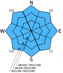
Avalanche danger remains LOW for all elevations and aspects. Minor surface wet snow instabilities are possible during the afternoon hours, but are not expected to present a significant hazard to backcountry travelers. Normal caution is advised.

1. Low

?

Above Treeline
Generally safe avalanche conditions. Watch for unstable snow on isolated terrain features.

1. Low

?

Near Treeline
Generally safe avalanche conditions. Watch for unstable snow on isolated terrain features.

1. Low

?

Below Treeline
Generally safe avalanche conditions. Watch for unstable snow on isolated terrain features.
    Generally safe avalanche conditions. Watch for unstable snow on isolated terrain features.
Avalanche Problem 1: Normal Caution
  • Type ?
  • Aspect/Elevation ?
  • Likelihood ?
    Certain
    Very Likely
    Likely
    Possible
    Unlikely
  • Size ?
    Historic
    Very Large
    Large
    Small

Air temperatures are around 5 degrees warmer this morning at the mid and upper elevations than they were 24 hours ago. Radiational cooling under clear skies combined with convective cooling from strong E winds last night are expected to have allowed for sufficient release of heat from the snowpack to have created a decent to solid overnight snow surface refreeze despite the warmer air temperatures. Wet surface snow will once again form in sun exposed areas in response to daytime warming. Convective cooling from moderate speed E winds is expected to slow the rate of snow surface melt in wind exposed areas. Small, minor wet snow instabilities are possible this afternoon in the form of human triggered roller balls, pinwheels, and/or small shallow loose wet avalanches. The size of any human triggered loose wet avalanche activity today is not expected to present a significant hazard to backcountry travelers.

Other hazards to manage today include exposed rocks on southerly aspects and difficult to travel firm icy surfaces on near and above treeline northerly aspects.

recent observations

Observations made yesterday on Mt. Houghton (Mount Rose area) showed a continued decrease in snow cover on SE-S-SW aspects and wet snow formation occurring in areas of sun exposure with wind protection. Convective cooling kept the snow surface exposed to the east winds on southerly aspects frozen at mid day despite direct sun exposure and above freezing air temperatures. At the same time, wind sheltered areas on southerly aspects between 9,400' and 10,400' held 1 to 3 inches of surface wet snow over very supportable melt-freeze crust at mid day.

Weather and CURRENT CONDITIONS
weather summary

High pressure will continue to deliver above average air temperatures and sunny skies through tomorrow morning. Ridgetop winds are decreasing this morning after peaking overnight with gusts to 76 mph over the Sierra Crest. Moderate speed east winds are expected to continue to slowly decrease over the next 24 hours, becoming light in speed by tomorrow morning. An air temperature inversion is well established across the region this morning with the coldest air settled down on mountain valley floors below 7,000'. Air temperatures in the 8,000' to 10,000' range are in the low 30s to low 40s this morning. Maximum daytime air temperatures are forecast to reach the mid 40s to mid 50s today for areas above 7,000'. For Monday, expect increasing cloud cover, light winds, and maximum daytime air temperatures about 5 degrees colder. Light precipitation enters the forecast Monday night.

CONDITIONS ALONG THE SIERRA CREST BETWEEN 8200 FT. AND 9200 FT. IN THE LAST 24 HOURS
6am temperature: 33 to 42 deg. F.
Max. temperature: 44 to 49 deg. F.
Average ridgetop wind direction: East
Average ridgetop wind speed: 40 mph
Maximum ridgetop wind gust: 76 mph
New snowfall: 0 inches
Total snow depth: 22 to 32 inches
Two-Day Mountain Weather Forecast Produced in partnership with the Reno NWS
For 7000 ft. to 8000 ft.
Sunday Sunday Night Monday
Weather: Sunny skies. Clear skies. Partly cloudy skies, becoming mostly cloudy.
Temperatures: 48 to 55 deg. F. 29 to 35 deg. F. 43 to 50 deg. F.
Mid Slope Winds: E E Variable
Wind Speed: 15 to 25 mph with gusts to 40 mph. Gusts decreasing to 30 mph in the afternoon. 10 to 15 mph with gusts to 25 mph in the evening. Light winds
Expected snowfall: 0 0 0
For 8000 ft. to 9000 ft.
Sunday Sunday Night Monday
Weather: Sunny skies. Clear skies. Partly cloudy skies, becoming mostly cloudy.
Temperatures: 46 to 53 deg. F. 28 to 35 deg. F. 39 to 46 deg. F.
Ridge Top Winds: E SE Variable
Wind Speed: 20 to 25 mph with gusts to 55 mph, decreasing to 15 to 25 mph with gusts to 40 mph in the afternoon. 15 to 25 mph with gusts to 35 mph in the evening. Light winds
Expected snowfall: 0 0 0
Disclaimer

This avalanche advisory is provided through a partnership between the Tahoe National Forest and the Sierra Avalanche Center. This advisory covers the Central Sierra Nevada Mountains between Yuba Pass on the north and Ebbetts Pass on the south. Click here for a map of the forecast area. This advisory applies only to backcountry areas outside established ski area boundaries. This advisory describes general avalanche conditions and local variations always occur. This advisory expires 24 hours after the posted time unless otherwise noted. The information in this advisory is provided by the USDA Forest Service who is solely responsible for its content.