THIS AVALANCHE FORECAST EXPIRED ON November 16, 2015 @ 7:01 am
Avalanche Forecast published on November 15, 2015 @ 7:01 am
Issued by Brandon Schwartz - Tahoe National Forest

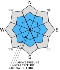
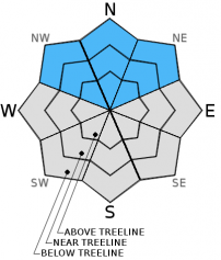
Early this morning, avalanche danger remains LOW for all elevations and aspects. Following the onset of snowfall, avalanche danger is expected to increase to CONSIDERABLE during the afternoon hours. Wind slabs and storms slabs are expected as the main avalanche problems.  Especially in areas that held snowcover prior to today's snowfall, natural and human triggered avalanches will be possible on slopes 35 degrees and steeper. The areas of greatest instability area expected near and above treeline on NW-N-NE-E aspects.

3. Considerable

?

Above Treeline
Dangerous avalanche conditions. Careful snowpack evaluation, cautious route-finding and conservative decision-making essential.

3. Considerable

?

Near Treeline
Dangerous avalanche conditions. Careful snowpack evaluation, cautious route-finding and conservative decision-making essential.

2. Moderate

?

Below Treeline
Heightened avalanche conditions on specific terrain features. Evaluate snow and terrain carefully; identify features of concern.
    Dangerous avalanche conditions. Careful snowpack evaluation, cautious route-finding and conservative decision-making essential.
Avalanche Problem 1: Wind Slab
  • Type ?
  • Aspect/Elevation ?
  • Likelihood ?
    Certain
    Very Likely
    Likely
    Possible
    Unlikely
  • Size ?
    Historic
    Very Large
    Large
    Small

Increasing southwest ridgetop winds began redistributing old snow on the ground yesterday. The combination of new snow and ongoing winds today will rapidly add depth to newly formed wind slabs. The majority of wind slabs are expected to form near treeline and above treeline on NW-N-NE-E aspects. Some smaller wind slabs may form in cross loaded areas on SE-S-SW-W aspects as well. Wind slabs are generally easy to identify and avoid. Look for areas of blowing snow, winds pillows, and cornice formation. Wind slabs tend to have fairly distinct top and side boundaries.

Avalanche Problem 2: Storm Slab
  • Type ?
  • Aspect/Elevation ?
  • Likelihood ?
    Certain
    Very Likely
    Likely
    Possible
    Unlikely
  • Size ?
    Historic
    Very Large
    Large
    Small

In many areas, new snow today will be deposited on top of near surface faceted snow crystals, especially on NW-N-NE aspects. In heavily shaded open areas, these near surface facets are fairly weak and sugary. The storm slab avalanche problem is most likely be found today in wind protected areas where new snow amounts approaching 1 foot are deposited on top of weak near surface facets. Storm slab boundaries are often not as distinct as wind slab boundaries. Storm slabs are dependent on continuity of a weak layer either at the old/new snow interface or within the new snow. This differs significantly from wind slabs that are dependent on wind drifted snow. Storm slabs with a significant weak layer at the old/new snow interface have greater potential to wrap around corners and can more easily be triggered from very low on a slope. Choose islands of safety well and continually consider the consequences of triggering from near the bottom of a slope.

recent observations

Observations made over the past several days in the Mount Rose, Donner Summit, and Carson Pass areas have indicated that significant melt has occurred on the sun expose E-SE-S-SW aspects, especially below 9,000'. NW-N-NE aspects have remained cold and hold a faceted snowpack ranging from 8 to 24 inches deep in wind protected areas. Snowpack depth tends to increase with elevation and is generally only a few inches deep below 7,300'. Faceted snowpack layers have been observed at all heights within the snowpack above 7,700' on NW-N-NE aspects. The degree of anchoring and degree of weakness from faceting varies widely from one location to another. With the existing snowpack fairly shallow, quick hand pits have been a good tool for searching out strong cohesive snow over weaker somewhat sugary snow in recent days.

Weather and CURRENT CONDITIONS
weather summary

A storm system tracking towards the forecast area will bring snow to the area later this morning. Snowfall intensity is expected to increase through the mid day and afternoon hours, tapering off after midnight. Total new snow amounts over the next 24 hours will vary across the forecast area with 10 to 14 inches expected along the Sierra Crest and 6 to 12 inches for other areas above 7,000'. New snow amounts below 7,000' are forecast to range from 2 to 8 inches with the higher amounts along and west of Hwy 89. Maximum daytime air temperatures are forecast for the mid 20s to mid 30s today for areas above 7,000'. These air temperatures will be significantly colder today than yesterday. Ridgetop winds are continuing to increase this morning with strong gusts over the ridgetops. Gale force wind gusts of 75 to 95 mph are forecast for later this morning.

CONDITIONS ALONG THE SIERRA CREST BETWEEN 8200 FT. AND 9200 FT. IN THE LAST 24 HOURS
6am temperature: 25 to 32 deg. F.
Max. temperature: 45 to 47 deg. F.
Average ridgetop wind direction: SW
Average ridgetop wind speed: 33 mph
Maximum ridgetop wind gust: 62 mph
New snowfall: 0 inches
Total snow depth: 8 to 18 inches
Two-Day Mountain Weather Forecast Produced in partnership with the Reno NWS
For 7000 ft. to 8000 ft.
Sunday Sunday Night Monday
Weather: Cloudy skies with show likely in the morning. Snow in the afternoon. Mostly cloudy skies. Snow in the evening. A slight chance of snow showers after midnight. Mostly cloudy skies, becoming partly cloudy.
Temperatures: 28 to 35 deg. F. 6 to 13 deg. F. 21 to 28 deg. F.
Mid Slope Winds: SW NW to N N
Wind Speed: 45 to 50 mph with gusts to 75 mph, decreasing to 20 to 25 mph with gusts to 40 mph in the afternoon. 15 to 20 mph with gusts to 30 mph, increasing to 25 to 30 mph with gusts to 40 mph after midnight. 25 to 35 mph with gusts to 55 mph.
Expected snowfall: 3 to 7 2 to 4 0
For 8000 ft. to 9000 ft.
Sunday Sunday Night Monday
Weather: Cloudy skies with show likely in the morning. Snow in the afternoon. Mostly cloudy skies. Snow in the evening. A slight chance of snow showers after midnight. Mostly cloudy skies, becoming partly cloudy.
Temperatures: 23 to 30 deg. F. 4 to 11 deg. F. 17 to 24 deg. F.
Ridge Top Winds: SW NW to N N
Wind Speed: 60 to 65 mph with gusts to 95 mph, decreasing to 30 to 35 mph with gusts to 50 mph in the afternoon. 30 to 35 mph with gusts to 50 mph, increasing to 40 to 45 mph with gusts to 70 mph after midnight. 40 to 50 mph with gusts to 75 mph.
Expected snowfall: 3 to 8 2 to 5 0
Disclaimer

This avalanche advisory is provided through a partnership between the Tahoe National Forest and the Sierra Avalanche Center. This advisory covers the Central Sierra Nevada Mountains between Yuba Pass on the north and Ebbetts Pass on the south. Click here for a map of the forecast area. This advisory applies only to backcountry areas outside established ski area boundaries. This advisory describes general avalanche conditions and local variations always occur. This advisory expires 24 hours after the posted time unless otherwise noted. The information in this advisory is provided by the USDA Forest Service who is solely responsible for its content.