THIS AVALANCHE FORECAST EXPIRED ON January 24, 2016 @ 6:59 am
Avalanche Forecast published on January 23, 2016 @ 6:59 am
Issued by Andy Anderson - Tahoe National Forest - Sierra Avalanche Center

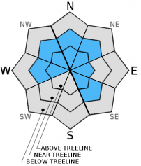
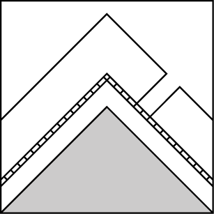
Human triggered avalanches are likely today on NW-N-NE-E aspects and some W and SE aspects at all elevations on slopes steeper than 32 degrees due to newly formed wind slabs and the possibility of deep persistent slabs. The avalanche danger is CONSIDERABLE today. Today's avalanches could be large and have severe consequences and may occur in areas traditionally considered safe especially in the case of the deep persistent slabs. Careful snowpack evaluation, cautious route-finding and conservative decision-making are essential.

3. Considerable

?

Above Treeline
Dangerous avalanche conditions. Careful snowpack evaluation, cautious route-finding and conservative decision-making essential.

3. Considerable

?

Near Treeline
Dangerous avalanche conditions. Careful snowpack evaluation, cautious route-finding and conservative decision-making essential.

3. Considerable

?

Below Treeline
Dangerous avalanche conditions. Careful snowpack evaluation, cautious route-finding and conservative decision-making essential.
    Dangerous avalanche conditions. Careful snowpack evaluation, cautious route-finding and conservative decision-making essential.
Avalanche Problem 1: Wind Slab
  • Type ?
  • Aspect/Elevation ?
  • Likelihood ?
    Certain
    Very Likely
    Likely
    Possible
    Unlikely
  • Size ?
    Historic
    Very Large
    Large
    Small

Strong south and southwest winds and 6 to 13 inches of dense new snow have formed new wind slabs on wind loaded NW-N-NE-E aspects and on some cross loaded W and SE aspects. Most of these new wind slabs will exist in exposed near and above treeline terrain, but some isolated open areas in below treeline terrain may also hold smaller wind slabs due to the strength of the winds. Human triggered wind slab avalanches are likely today on wind loaded slopes steeper than 34 degrees. These new wind slabs will consist of heavy dense snow and could result in destructive avalanches that will easily involve enough snow to bury or injure people. 

Avalanche Problem 2: Deep Slab
  • Type ?
  • Aspect/Elevation ?
  • Likelihood ?
    Certain
    Very Likely
    Likely
    Possible
    Unlikely
  • Size ?
    Historic
    Very Large
    Large
    Small

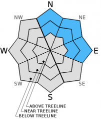
Buried surface hoar still exists on open slopes on some near and below treeline N-NE-E aspects. This layer could still exist on some isolated NW and SE aspects as well. This persistent weak layer was still reactive before this storm, and now the storm has added another 6 to 13 inches of heavy wet snow on top of the 2-3 ft. slab that already existed on top of the surface hoar layer. Triggering an avalanche on these buried surface hoar layers will be possible on slopes steeper than 32 degrees where the surface hoar exists. These deep persistent slab avalanches would be large and have severe consequences. Avalanches that fail on buried surface hoar can propagate long distances, can occur in places traditionally considered safe, and can be triggered from lower angle terrain. 

Due to the consequences of these types of avalanches, avoiding steep slopes where reactive surface hoar still exists represents the best way to manage this avalanche problem. Unfortunately, determining where the buried surface hoar still exists and where it is still reactive is difficult. Recent avalanche activity, shooting cracks, collapsing, whumpfing, and snowpit tests can provide some clues. However, a persistent slab triggered by a party on the slope sometimes represents the first and only clue to avalanche instability. 

recent observations

Yesterday observations from Red Lake Peak on Carson Pass and the Fireplug in the Mt. Rose backcountry found strong winds and blowing snow already starting to occur as of midday. In each of these areas old avalanches existed with recent snow and wind transported snow obscuring the details of these older avalanches. Snowpit data and general observations on the N-NE-E aspects in the Fireplug area did not find any lingering signs of instability or persistent weak layers in the snowpack. On Red Lake Peak some splitboarder triggered cracking did occur. In both areas southerly facing slopes had breakable and supportable crusts on the surface, and northerly aspects above 7500 ft. had a heavy layer of soft snow sitting on top of a lighter layer of recent snow. Below 7500 ft. rain crusts existed on all aspects on Red Lake Peak. 

Weather and CURRENT CONDITIONS
weather summary

Snow, rain, and wind started to hammer the forecast area yesterday afternoon. South and southwest winds that averaged 50 mph with gusts to 90 mph persisted through the night. Snow levels stayed between 6700 and 8000 ft. until about 3 am when a cold front moved through the area. Since then snow levels have fallen to around 5000 ft. Most precipitation fell before the cold front passed through the area in the form of rain below 7500 ft. and heavy wet snow above 7500 ft. Upper elevation areas around the region reported 10 to 13 inches of new snow in the last 24 hours. Below 7500 ft. most of this precipitation fell as 1.4 to 1.9 inches of water. The storm has started to taper off and should continue to move eastward out of the area today. Some light snow showers may continue in the mountains today, but the forecast only calls for another 1 to 3 inches of additional accumulation. Winds should also start to decrease and begin shifting towards the north. Expect clearing skies, cold temperatures, and light to moderate north winds tonight and tomorrow.

CONDITIONS ALONG THE SIERRA CREST BETWEEN 8200 FT. AND 9200 FT. IN THE LAST 24 HOURS
6am temperature: 21 to 30 deg. F.
Max. temperature: 31 to 36 deg. F.
Average ridgetop wind direction: South to southwest
Average ridgetop wind speed: 40 to 50 mph
Maximum ridgetop wind gust: 90 mph
New snowfall: 6 to 13 inches
Total snow depth: 75 to 82 inches
Two-Day Mountain Weather Forecast Produced in partnership with the Reno NWS
For 7000 ft. to 8000 ft.
Saturday Saturday Night Sunday
Weather: Cloudy with occasional snow showers Mostly cloudy with snow likely in the evening and a chance of snow continuing after midnight Mostly cloudy
Temperatures: 27 to 34 deg. F. 16 to 22 deg. F. 27 to 34 deg. F.
Mid Slope Winds: Southwest Northwest Northwest
Wind Speed: 15 to 25 mph with gusts to 40 mph 10 to 20 mph 10 to 15 mph with gusts to 25 mph in the morning becoming light in the afternoon
Expected snowfall: 1 to 3 up to 2 0
For 8000 ft. to 9000 ft.
Saturday Saturday Night Sunday
Weather: Cloudy with occasional snow showers Mostly cloudy with snow likely in the evening and a chance of snow continuing after midnight Mostly cloudy
Temperatures: 24 to 31 deg. F. 10 to 17 deg. F. 23 to 30 deg. F.
Ridge Top Winds: Southwest Southwest shifting to north after midnight North
Wind Speed: 40 to 50 mph with gusts to 75 mph 30 to 35 mph with gusts to 55 mph decreasing to 15 to 20 mph with gusts to 30 mph after midnight 15 to 20 mph with gusts to 35 mph decreasing to 25 mph in the afternoon
Expected snowfall: 1 to 3 up to 2 0
Disclaimer

This avalanche advisory is provided through a partnership between the Tahoe National Forest and the Sierra Avalanche Center. This advisory covers the Central Sierra Nevada Mountains between Yuba Pass on the north and Ebbetts Pass on the south. Click here for a map of the forecast area. This advisory applies only to backcountry areas outside established ski area boundaries. This advisory describes general avalanche conditions and local variations always occur. This advisory expires 24 hours after the posted time unless otherwise noted. The information in this advisory is provided by the USDA Forest Service who is solely responsible for its content.