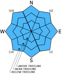
THIS AVALANCHE FORECAST EXPIRED ON February 18, 2016 @ 6:50 am
Avalanche Forecast published on February 17, 2016 @ 6:50 am
Issued by Steve Reynaud - Tahoe National Forest

Avalanche danger remains low on all aspects and elevations through the daytime hours today.  Normal caution is advised.  As the incoming storm arrives, avalanche danger will quickly rise into tonight and through tomorrow.  Natural avalanche activity will become likely this evening and into the early morning hours.

1. Low

?

Above Treeline
Generally safe avalanche conditions. Watch for unstable snow on isolated terrain features.

1. Low

?

Near Treeline
Generally safe avalanche conditions. Watch for unstable snow on isolated terrain features.

1. Low

?

Below Treeline
Generally safe avalanche conditions. Watch for unstable snow on isolated terrain features.
    Generally safe avalanche conditions. Watch for unstable snow on isolated terrain features.
Avalanche Problem 1: Normal Caution
  • Type ?
  • Aspect/Elevation ?

A strong winter storm will impact our forecast area today.  Gale force winds are forecasted to be 60 to 70mph with gusts over 100mph above 8000'. With the winds and cloud cover no melting of the snow surface is expected throughout today.  Firm snow surface conditions could be encountered in most wind exposed areas.  Any precipitation today that falls should be either light rain or snow and should have limited impacts in the daylight hours.  As evening approaches, the storm intensifies and snowfall rates increase to 2 to 3'' per hour.  Avalanche danger will quickly rise with natural avalanche activity becoming likely from this evening into Thursday.

Normal caution means exercising basic travel techniques.  Travel one at a time in avalanche terrain, regroup in safe spots out of the avalanche path, avoid travel near terrain traps, and practice effective communication within your group.

recent observations

Observations throughout the last week show a well bonded snowpack ready for additional load.  On shaded aspects, the snowpack is made up of mostly crusts and strong rounded snow with no indications of any problematic layers for the future.  Solar aspects have established melt freeze crusts and have had mostly supportable skiing conditions.

Observations from Meiss Meadows (Carson Pass area) and Angora Peak (Echo Peak area) both showed melt freeze crusts softening throughout the day.  On northerly aspects in both areas, snowpack tests showed no signs of any weaknesses around the many crusts in the upper snowpack.  On Angora Peak, areas of minimal snow coverage on solar aspects became unsupportable around midday.  Although, no signs of loose wet avalanche activity was observed.

Weather and CURRENT CONDITIONS
weather summary

A strong winter storm will impact our region today through Thursday.  Pre frontal winds today will be 60 to 70mph gusting over 100mph above 8000'.  The heaviest snow is expected tonight between 10pm and 8am Thursday morning where snowfall rates could exceed 2 to 3'' per hour.  12 to 20'' of snow is forecasted for the Sierra Crest above 7000'.  Snow levels should start between 6500-7500' and drop quickly to valley floors.  A wind advisory is in effect for all of today and a winter storm warning is in effect from 7pm tonight through noon Thursday.

CONDITIONS ALONG THE SIERRA CREST BETWEEN 8200 FT. AND 9200 FT. IN THE LAST 24 HOURS
6am temperature: 33 to 37 deg. F.
Max. temperature: 54 deg. F.
Average ridgetop wind direction: SW
Average ridgetop wind speed: 50 to 75 mph
Maximum ridgetop wind gust: 102 mph
New snowfall: 0 inches
Total snow depth: 58 to 76 inches
Two-Day Mountain Weather Forecast Produced in partnership with the Reno NWS
For 7000 ft. to 8000 ft.
Wednesday Wednesday Night Thursday
Weather: Mostly cloudy then becoming cloudy. Slight chance of rain and snow. Cloudy, snow. Cloudy. Snow in the morning then snow likely in the afternoon.
Temperatures: 40 to 47 deg. F. 19 to 26 deg. F. 27 to 34 deg. F.
Mid Slope Winds: SW SW SW
Wind Speed: 45 to 50mph with gusts to 75mph increasing to 55 to 60mph with gusts to 90mph in the afternoon. 50 to 60mph with gusts to 95mph decreasing to 80mph after midnight. 30 to 40mph with gusts to 60mph.
Expected snowfall: Up to 1 6 to 12 1 to 4
For 8000 ft. to 9000 ft.
Wednesday Wednesday Night Thursday
Weather: Mostly cloudy then becoming cloudy. Slight chance of rain and snow. Cloudy, snow. Cloudy. Snow in the morning then snow likely in the afternoon.
Temperatures: 36 to 43 deg. F. 17 to 24 deg. F. 24 to 31 deg. F.
Ridge Top Winds: SW SW SW
Wind Speed: 60 to 70mph with gusts to 95mph increasing to 105mph in the afternoon. 65 to 75mph with gusts to 115mph. 50 to 60mph with gusts to 85mph.
Expected snowfall: Up to 1 8 to 15 1 to 4
Disclaimer

This avalanche advisory is provided through a partnership between the Tahoe National Forest and the Sierra Avalanche Center. This advisory covers the Central Sierra Nevada Mountains between Yuba Pass on the north and Ebbetts Pass on the south. Click here for a map of the forecast area. This advisory applies only to backcountry areas outside established ski area boundaries. This advisory describes general avalanche conditions and local variations always occur. This advisory expires 24 hours after the posted time unless otherwise noted. The information in this advisory is provided by the USDA Forest Service who is solely responsible for its content.