THIS AVALANCHE FORECAST EXPIRED ON March 2, 2016 @ 6:56 am
Avalanche Forecast published on March 1, 2016 @ 6:56 am
Issued by Steve Reynaud - Tahoe National Forest

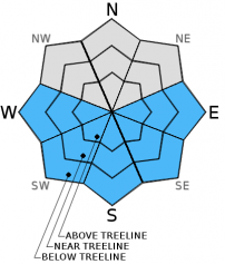
Low avalanche danger exists through the early morning hours on all aspects and elevations.  As daytime warming occurs, avalanche danger will rise to Moderate on E-SE-S-SW-W aspects on slopes steeper than 35 degrees due to the possibility of loose wet instabilities.


2. Moderate

?

Above Treeline
Heightened avalanche conditions on specific terrain features. Evaluate snow and terrain carefully; identify features of concern.

2. Moderate

?

Near Treeline
Heightened avalanche conditions on specific terrain features. Evaluate snow and terrain carefully; identify features of concern.

2. Moderate

?

Below Treeline
Heightened avalanche conditions on specific terrain features. Evaluate snow and terrain carefully; identify features of concern.
    Heightened avalanche conditions on specific terrain features. Evaluate snow and terrain carefully; identify features of concern.
Avalanche Problem 1: Loose Wet
  • Type ?
  • Aspect/Elevation ?
  • Likelihood ?
    Certain
    Very Likely
    Likely
    Possible
    Unlikely
  • Size ?
    Historic
    Very Large
    Large
    Small

A moderate snow surface refreeze is expected to have occurred last night with mostly above freezing temperatures and increased thin cloud cover compared with yesterday.  Increasing winds today will help to keep the snow surface cool and delay snow surface melt mostly in near treeline and above treeline terrain.  In wind exposed areas, the snow surface may not soften at all today.  In wind protected gullies, rock features, and below treeline areas little to no delay in warming may occur due to the increased winds and cloud cover.  Wet snow instabilities are expected to form on E-SE-S-SW-W aspects on slopes steeper than 35 degrees in wind protected and below treeline terrain during the late morning and early afternoon hours as daytime warming occurs. 

Recent roller balls or pinwheels are an indication that the snow surface is loosing strength and that loose wet avalanches are becoming possible.  Use boot penetration to constantly monitor the supportability of the snow surface.  If boot penetration exceeds 10-12 inches into wet snow, it's time to move to a less sun exposed aspect and/or terrain under 30 degrees without steeper terrain above.


recent observations

Observations from Tamarack Peak and Mt. Houghton (Mt. Rose area) showed similar conditions that have been reported over the last few days through the forecast area.  Melt freeze crusts have formed on most SE-S-SW aspects providing skier supportable snow conditions with "corn snow" as daytime warming occurs.  Transitional snow exists on mid to low elevation NW-N-NE aspects along with upper elevation East aspects where a thin crust or several inches of wet snow exist on top of colder dryer snow that has not undergone the melt freeze process.  Pockets of unconsolidated snow and wind effected snow can be found on the most shaded northerly aspects.

Weather and CURRENT CONDITIONS
weather summary

A weak low pressure has moved into the Pacific NW and is bringing us high thin clouds and more wind for today.   Most areas will remain dry with above average temperatures through Thursday.  SW winds are forecasted to be in the strong to gale force range with gusts expected up to 80mph on ridges and peaks above 8000'.  Remote sensors reported overnight temperatures above 8000' in the mid 30's to low 40's.  Daytime temperatures are expected to be in the mid 40's to mid 50's above 7000' today.

CONDITIONS ALONG THE SIERRA CREST BETWEEN 8200 FT. AND 9200 FT. IN THE LAST 24 HOURS
6am temperature: 33 to 40 deg. F.
Max. temperature: 45 deg. F.
Average ridgetop wind direction: SW
Average ridgetop wind speed: 15 to 20 mph
Maximum ridgetop wind gust: 35 mph
New snowfall: 0 inches
Total snow depth: 54 to 84 inches
Two-Day Mountain Weather Forecast Produced in partnership with the Reno NWS
For 7000 ft. to 8000 ft.
Tuesday Tuesday Night Wednesday
Weather: Mostly cloudy then becoming partly cloudy. Partly cloudy. Partly cloudy.
Temperatures: 50 to 58 deg. F. 31 to 37 deg. F. 51 to 59 deg. F.
Mid Slope Winds: SW SW SW
Wind Speed: 15 to 20mph with gusts to 30mph increasing to 25 to 30mph with gusts to 45mph in the afternoon. 20 to 30mph with gusts to 45mph decreasing to 35mph after midnight. 10 to 15mph with gusts to 25mph increasing to 20 to 25mph with gusts to 40mph in the afternoon.
Expected snowfall: 0 0 0
For 8000 ft. to 9000 ft.
Tuesday Tuesday Night Wednesday
Weather: Partly cloudy. Partly cloudy. Partly cloudy.
Temperatures: 45 to 51 deg. F. 26 to 33 deg. F. 46 to 52 deg. F.
Ridge Top Winds: SW SW SW
Wind Speed: 30 to 35mph with gusts to 50mph increasing to 45 to 50mph with gusts to 80mph in the afternoon. 50 to 55mph with gusts to 80mph decreasing to 30 to 35mph with gusts to 55mph after midnight. 30 to 35mph with gusts to 50mph increasing to 40 to 45mph with gusts to 70mph in the afternoon.
Expected snowfall: 0 0 0
Disclaimer

This avalanche advisory is provided through a partnership between the Tahoe National Forest and the Sierra Avalanche Center. This advisory covers the Central Sierra Nevada Mountains between Yuba Pass on the north and Ebbetts Pass on the south. Click here for a map of the forecast area. This advisory applies only to backcountry areas outside established ski area boundaries. This advisory describes general avalanche conditions and local variations always occur. This advisory expires 24 hours after the posted time unless otherwise noted. The information in this advisory is provided by the USDA Forest Service who is solely responsible for its content.