THIS AVALANCHE FORECAST EXPIRED ON March 4, 2016 @ 6:57 am
Avalanche Forecast published on March 3, 2016 @ 6:57 am
Issued by Andy Anderson - Tahoe National Forest - Sierra Avalanche Center

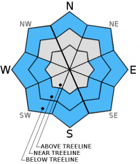
The avalanche danger will remain LOW today. As the day warms up, some small loose wet snow instabilities may still form on isolated terrain features below 8500 ft. on sun-exposed aspects, on slopes where wet snow exists on top of drier snow, or on slopes that receive rain today. Use normal caution when traveling in the backcountry. 

1. Low

?

Above Treeline
Generally safe avalanche conditions. Watch for unstable snow on isolated terrain features.

1. Low

?

Near Treeline
Generally safe avalanche conditions. Watch for unstable snow on isolated terrain features.

1. Low

?

Below Treeline
Generally safe avalanche conditions. Watch for unstable snow on isolated terrain features.
    Generally safe avalanche conditions. Watch for unstable snow on isolated terrain features.
Avalanche Problem 1: Loose Wet
  • Type ?
  • Aspect/Elevation ?
  • Likelihood ?
    Certain
    Very Likely
    Likely
    Possible
    Unlikely
  • Size ?
    Historic
    Very Large
    Large
    Small

Despite a weak overnight refreeze, cloudy skies, increased winds, slightly cooler temperatures, and the fact that the snowpack has been through a prolonged melt-freeze cycle should limit the formation of wet snow instabilities today. Some small isolated loose wet snow instabilities like roller balls, pinwheels, and the occasional point release may still form on isolated terrain features below 8500 ft. East and west facing slopes where wet snow forms above drier snow will represent the most likely places for some loose wet snow instabilities to form, but they could occur on isolated sun-exposed SE-S-SW aspects or even on some low elevation isolated northerly aspects as well. If any slopes receive rain today loose wet instabilities could also form on those slopes. Again, any wet snow instabilities that do form today should remain small and isolated and only occur on specific terrain features. Larger more problematic wet snow issues will remain unlikely today.

recent observations

Yesterday observations showed corn snow conditions on the SE-S-SW aspects of Castle Peak (Donner Summit area) and in the Third Creek drainage (Mt. Rose backcountry). In both of these areas, 2 to 4 inches of soft wet corn snow existed above a supportable melt-freeze crust by mid-morning and lasted through the afternoon on the exposed upper elevation slopes. At the lower elevations deeper unsupportable wet snow existed. Observations on the northerly aspects of Castle Peak and in the Third Creek area showed a mix of surface conditions ranging from some wet snow at the lower elevations to breakable crusts, firm surfaces, and colder drier snow above 8000 ft. Snowpit tests did not show any signs of instability on these slopes.

Weather and CURRENT CONDITIONS
weather summary

The strong high pressure ridge over the region should begin to move east today allowing a weak low pressure to move past the forecast area to the north. This change should bring increased wind and cloud cover to the region today and possibly some light rain or snow to the forecast area north of I-80. If these showers do occur accumulations would remain small and snow levels would remain high between 7500 and 8500 ft. Temperatures should cool a few degrees but remain warm with daytime highs in the 40's today and tomorrow. The winds should decrease some tomorrow during the mid morning hours before increasing again tomorrow afternoon as the first part of a strong storm approaches the region. For more details check out the Reno NWS.

CONDITIONS ALONG THE SIERRA CREST BETWEEN 8200 FT. AND 9200 FT. IN THE LAST 24 HOURS
6am temperature: 34 to 38 deg. F.
Max. temperature: 46 to 51 deg. F.
Average ridgetop wind direction: Southwest
Average ridgetop wind speed: 25 to 35 mph
Maximum ridgetop wind gust: 56 mph
New snowfall: 0 inches
Total snow depth: 53 to 82 inches
Two-Day Mountain Weather Forecast Produced in partnership with the Reno NWS
For 7000 ft. to 8000 ft.
Thursday Thursday Night Friday
Weather: Partly cloudy becoming mostly cloudy with a 30% chance of rain showers north of I-80. Snow level between 7500 and 8500 ft. Mostly cloudy with a 30% chance of rain showers north of I-80. Snow level between 7500 and 8500 ft. Mostly cloudy with a 30% chance of rain showers north of I-80. Snow level between 7500 and 8500 ft.
Temperatures: 41 to 48 deg. F. 25 to 32 deg. F. 42 to 49 deg. F.
Mid Slope Winds: Southwest Southwest Southwest
Wind Speed: 15 to 25 mph with gusts to 35 mph 15 to 20 mph with gusts to 30 mph 10 to 20 mph with gusts to 30 mph
Expected snowfall: Rain: less than .1 Rain: less than .1 Rain: less than .1
For 8000 ft. to 9000 ft.
Thursday Thursday Night Friday
Weather: Partly cloudy becoming mostly cloudy with a 30% chance of snow showers north of I-80. Snow level between 7500 and 8500 ft. Mostly cloudy with a 30% chance of snow showers north of I-80. Snow level between 7500 and 8500 ft. Mostly cloudy with a 30% chance of snow and rain showers north of I-80. Snow level between 7500 and 8500 ft.
Temperatures: 37 to 44 deg. F. 26 to 33 deg. F. 36 to 43 deg. F.
Ridge Top Winds: Southwest Southwest Southwest
Wind Speed: 30 to 40 mph with gusts to 60 mph 25 to 35 mph with gusts to 50 mph 30 to 40 mph with gusts to 60 mph
Expected snowfall: up to 1 up to 1 up to 1
Disclaimer

This avalanche advisory is provided through a partnership between the Tahoe National Forest and the Sierra Avalanche Center. This advisory covers the Central Sierra Nevada Mountains between Yuba Pass on the north and Ebbetts Pass on the south. Click here for a map of the forecast area. This advisory applies only to backcountry areas outside established ski area boundaries. This advisory describes general avalanche conditions and local variations always occur. This advisory expires 24 hours after the posted time unless otherwise noted. The information in this advisory is provided by the USDA Forest Service who is solely responsible for its content.