THIS AVALANCHE FORECAST EXPIRED ON March 8, 2016 @ 6:56 am
Avalanche Forecast published on March 7, 2016 @ 6:56 am
Issued by Brandon Schwartz - Tahoe National Forest

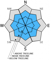
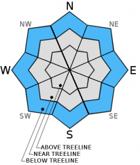
On the heels of another period of HIGH avalanche danger last night, CONSIDERABLE avalanche danger will exist today near and above treeline on all aspects on slopes 35 degrees and steeper due to ongoing wind slab formation. In wind protected areas below treeline, MODERATE avalanche danger exists on slopes 35 degrees and steeper due to potential storm slabs. Large human triggered avalanches remain likely today. Natural avalanches are possible.

3. Considerable

?

Above Treeline
Dangerous avalanche conditions. Careful snowpack evaluation, cautious route-finding and conservative decision-making essential.

3. Considerable

?

Near Treeline
Dangerous avalanche conditions. Careful snowpack evaluation, cautious route-finding and conservative decision-making essential.

2. Moderate

?

Below Treeline
Heightened avalanche conditions on specific terrain features. Evaluate snow and terrain carefully; identify features of concern.
    Dangerous avalanche conditions. Careful snowpack evaluation, cautious route-finding and conservative decision-making essential.
Avalanche Problem 1: Wind Slab
  • Type ?
  • Aspect/Elevation ?
  • Likelihood ?
    Certain
    Very Likely
    Likely
    Possible
    Unlikely
  • Size ?
    Historic
    Very Large
    Large
    Small

Ongoing gale force SW winds this morning will continue to transport snow and build problematic wind slabs in near and above treeline areas. In some cases wind slabs may exist below treeline as well. The vast majority of wind slabs are expected on wind loaded NW-N-NE-E-SE aspects. Wind slabs may exist on S-SW-W aspects, especially after winds shift to the NW this afternoon and change the pattern of distribution. Human triggered avalanches are likely today and large avalanches could occur. In the areas of direct wind loading, natural avalanches remain possible.

Identify and avoid steep wind loaded slopes. Use clues such as recent avalanche activity, blowing snow, cornice formation, wind pillows, and snow surface patterning to determine where wind loading is actively occurring or has occurred recently.

Avalanche Problem 2: Storm Slab
  • Type ?
  • Aspect/Elevation ?
  • Likelihood ?
    Certain
    Very Likely
    Likely
    Possible
    Unlikely
  • Size ?
    Historic
    Very Large
    Large
    Small

In wind protected areas below treeline, human triggered storm slabs are possible today. Short lived weak layers within the new snow from last night may remain reactive during the day today. Clues such as recent avalanche activity and cracking in wind protected areas are obvious indications of storm slab instability. Keep in mind that treed areas can protect from the wind and wind related avalanche problems but not from storm slabs. Seek out lower angle (sub 30 degree) slopes without steeper terrain above when signs of instability are present.

recent observations

Observations made and received yesterday from Powderhouse Peak (Luther Pass area), Hidden Peak (West Shore Tahoe area), Tamarack Peak (Mount Rose area), and Andesite Peak (Donner Summit area) found a wide range of snowpack instability. Evidence of instability ranged from natural and human triggered wind slab avalanches to signs of instability limited to the presence of recent new snow and blowing snow. On Hidden Peak, the signs of a natural wind slab avalanche were observed along the summit ridge, with widespread skier triggered cracking noted in wind loaded areas near treeline within the top 300' to 400' of the peak. Similar conditions were observed on Powderhouse Peak with an intentionally snowboarder triggered wind slab on a small test slope. A trailhead report of a skier triggered avalanche involving 1 to 2 people in the Fireplug area near Tamarack Peak was received, but details are few. A second report of a very small skier triggered wind slab was also received from the Fireplug area. See below for more info, video, and photos.

Weather and CURRENT CONDITIONS
weather summary

Another storm system is moving through the region. Snow levels are down around 3,000' to 4,000' this morning. As of 5:30 am, new snow amounts above 7,000' over the past 18 hours range from 8 to 12 inches. Snowfall is expected to continue through the day today, possibly becoming higher intensity during the afternoon hours. Continued gale force SW ridgetop winds are forecast to continue through this morning, shifting to NW and decreasing to moderate speed this afternoon. Maximum daytime air temperatures above 7,000' are expected to remain in the 20s today, possibly reaching near freezing is some areas. A period of NE winds is expected tonight before winds shift back to the SW tomorrow. Clearing is forecast to occur tonight into Tuesday with maximum daytime air temperatures above 7,000' reaching near to above freezing.

Since Friday afternoon, the forecast area has received 3 to 5 inches of rain water equivalent with 2 to 4 feet of snow above 8,000'.

CONDITIONS ALONG THE SIERRA CREST BETWEEN 8200 FT. AND 9200 FT. IN THE LAST 24 HOURS
6am temperature: 21 to 25 deg. F.
Max. temperature: 26 to 31 deg. F.
Average ridgetop wind direction: SW
Average ridgetop wind speed: 40 mph
Maximum ridgetop wind gust: 76 mph
New snowfall: 8 to 12 inches
Total snow depth: 73 to 109 inches
Two-Day Mountain Weather Forecast Produced in partnership with the Reno NWS
For 7000 ft. to 8000 ft.
Monday Monday Night Tuesday
Weather: Cloudy skies with snow in the morning. Snow showers in the afternoon. Mostly cloudy skies becoming partly cloudy. A chance of snow showers in the evening. A slight chance of snow showers after midnight. Partly cloudy skies. A slight chance of snow showers in the morning.
Temperatures: 25 to 32 deg. F. 12 to 19 deg. F. 32 to 39 deg. F.
Mid Slope Winds: SW shifting to NW N S
Wind Speed: 35 to 40 mph with gusts to 55 mph, shifting and decreasing to 10 to 15 mph in the afternoon. 10 to 15 mph with gusts to 25 mph. Light winds increasing to 10 to 15 mph with gusts to 25 mph in the afternoon.
Expected snowfall: 3 to 6 Up to 1 0 to trace
For 8000 ft. to 9000 ft.
Monday Monday Night Tuesday
Weather: Cloudy skies with snow in the morning. Snow showers in the afternoon. Mostly cloudy skies becoming partly cloudy. A chance of snow showers in the evening. A slight chance of snow showers after midnight. Partly cloudy skies. A slight chance of snow showers in the morning.
Temperatures: 20 to 27 deg. F. 10 to 17 deg. F. 29 to 36 deg. F.
Ridge Top Winds: SW shifting to NW N NE shifting to SW
Wind Speed: 55 to 60 mph with gusts to 85 mph, shifting and decreasing to 15 to 20 mph with gusts to 35 mph in the afternoon. 20 to 30 mph with gusts to 45 mph. 10 to 15 mph shifting and increasing to 20 to 25 mph with gusts to 35 mph in the afternoon.
Expected snowfall: 3 to 6 Up to 1 0 to trace
Disclaimer

This avalanche advisory is provided through a partnership between the Tahoe National Forest and the Sierra Avalanche Center. This advisory covers the Central Sierra Nevada Mountains between Yuba Pass on the north and Ebbetts Pass on the south. Click here for a map of the forecast area. This advisory applies only to backcountry areas outside established ski area boundaries. This advisory describes general avalanche conditions and local variations always occur. This advisory expires 24 hours after the posted time unless otherwise noted. The information in this advisory is provided by the USDA Forest Service who is solely responsible for its content.