In partnership with: 
| Date and time of observation or avalanche occurrence | Location | Media | Observation made by |
|---|---|---|---|
|
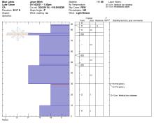
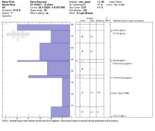
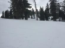
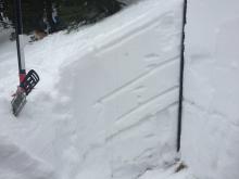
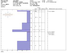
01/17/2021 - 11:00 Snowpack Observation |
Stevens Peak Carson Pass Area |
    |
Forecaster |
|
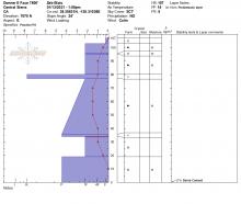
01/16/2021 - 14:00 Snowpack Observation |
Andesite Peak Donner Summit Area |
Educator Alpenglow Expeditio |
|
|
01/16/2021 - 10:30 Snowpack Observation |
Silver Peak Cabin Creek, Deep Creek, or Pole Creek Area |
     |
Forecaster |
|
01/15/2021 - 11:00 Snowpack Observation |
Castle Peak Donner Summit Area |
    |
Forecaster |
|
01/15/2021 - 10:45 Snowpack Observation |
Andesite Peak Donner Summit Area |
 |
Educator Outdoor Adventure Cl |
|
01/14/2021 - 12:00 Snowpack Observation |
Blue lakes Carson Pass Area |
    |
Professional Observer |
|
01/14/2021 - 11:00 Snowpack Observation |
Relay Peak Mount Rose Area |
     |
Forecaster |
|
01/14/2021 - 10:30 Snowpack Observation |
Melissa Coray Peak Carson Pass Area |
Public | |
|
01/13/2021 - 14:00 Snowpack Observation |
just north of white rock lake Independence Lake Area |
Public | |
|
01/13/2021 - 13:30 Snowpack Observation |
Donner Peak Donner Summit Area |
 |
Guide Blackbird Mountain Guid |
|
01/13/2021 - 12:30 Snowpack Observation |
Becker Peak Echo Summit Area |
 |
Public |
|
01/13/2021 - 10:00 Snowpack Observation |
Mt. Lola Independence Lake Area |
     |
Forecaster |
|
01/13/2021 - 09:00 Snowpack Observation |
Silver Peak Cabin Creek, Deep Creek, or Pole Creek Area |
     |
Forecaster |
|
01/12/2021 - 14:30 Snowpack Observation |
Chickadee Ridge Mount Rose Area |
  |
Public |
|
01/12/2021 - 11:30 Snowpack Observation |
Red Lake Peak Carson Pass Area |
|
Professional Observer |


This website is owned and maintained by the non-profit arm of the Sierra Avalanche Center. Some of the content is updated by the USDA avalanche forecasters including the forecasts and some observational data. The USDA is not responsible for any advertising, fund-raising events/information, or sponsorship information, or other content not related to the forecasts and the data pertaining to the forecasts.