THIS AVALANCHE FORECAST EXPIRED ON April 3, 2014 @ 6:58 am
Avalanche Forecast published on April 2, 2014 @ 6:58 am
Issued by Brandon Schwartz - Tahoe National Forest

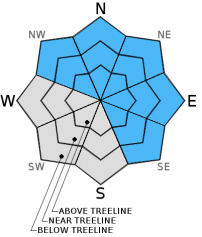
Areas of MODERATE avalanche danger remain in recently wind loaded areas at all elevations on NW-N-NE-E-SE aspects on slopes 35 degrees and steeper due to the presence of wind slabs and persistent slabs. For all other areas, avalanche danger is LOW.

2. Moderate

?

Above Treeline
Heightened avalanche conditions on specific terrain features. Evaluate snow and terrain carefully; identify features of concern.

2. Moderate

?

Near Treeline
Heightened avalanche conditions on specific terrain features. Evaluate snow and terrain carefully; identify features of concern.

2. Moderate

?

Below Treeline
Heightened avalanche conditions on specific terrain features. Evaluate snow and terrain carefully; identify features of concern.
    Heightened avalanche conditions on specific terrain features. Evaluate snow and terrain carefully; identify features of concern.
Avalanche Problem 1: Wind Slab
  • Type ?
  • Aspect/Elevation ?
  • Likelihood ?
    Certain
    Very Likely
    Likely
    Possible
    Unlikely
  • Size ?
    Historic
    Very Large
    Large
    Small

Lingering wind slabs exist in recently wind loaded areas at all elevations on NW-N-NE-E-SE aspects. Ongoing instability was observed yesterday during the late afternoon hours. Human triggered avalanches remain possible today in these areas. Areas below cornice features that receive the most direct wind loading will be the most suspect today.

Avalanche Problem 2: Persistent Slab
  • Type ?
  • Aspect/Elevation ?
  • Likelihood ?
    Certain
    Very Likely
    Likely
    Possible
    Unlikely
  • Size ?
    Historic
    Very Large
    Large
    Small

Persistent slabs exist above 7,800' on NW-N-NE-E-SE aspects due the presence of a weak layer of near crust facets at the base of the recent storm snow. In some areas this weak layer is buried as little as 1.5 feet deep and in other areas is qualifies as a Deep Persistent Slab with the weak layer buried 3-4+ feet deep. Creating collapse of the weak layer is becoming increasingly difficult, especially in areas where the weak layer is buried over 3 feet deep. Large triggers such as wind slab avalanches, large cornice collapses, or multiple people on the same slope are likely required to trigger collapse in most areas. In the more isolated areas where this weak layer is less the 2 feet below the snow surface, triggering will be easier.

Forecast discussion

Sun breaks today are expected to allow for short periods of rapid warming. Below average air temperatures are expected to help keep areas of wet snow instability to a minimum today. Isolated areas of roller balls and small pinwheels may occur today on all aspects as snow falls off of trees and rocks. The expected minimal amount of loose wet instability that occurs today is not expected to involve loose wet avalanches. If cloud cover decreases more than forecast or air temperatures warm more than forecast, the amount of loose wet instability will be greater than forecast.

recent observations

Observations made yesterday on Andesite Ridge (Donner Summit area) and on Stevens Peak (Carson Pass area) revealed ongoing unstable wind slabs. Recently wind loaded areas held wind slabs that contributed to a couple of isolated small natural avalanches. Skier triggered cracking was prevalent in these same recently wind loaded areas at 4 pm. On Stevens Peak a 10ft radius collapse was skier triggered on an ESE low angle feature at 9,000ft. The collapse occurred approximately 16 inches down, consistent with the depth of the near crust facet layer in that area. On the Andesite Ridge area, the near crust facet layer was observed buried over 4ft down on a minimally wind loaded NE aspect at 7,900' and was unreactive in snowpit tests.

Weather and CURRENT CONDITIONS
weather summary

A low pressure system tracking southeast down the California coast has kept snow showers ongoing along the Sierra Crest. For today expect mostly cloudy skies with off and on periods of snow showers and sun breaks. Ridgetop winds shifted from southwest to east over the last 24 hours and are light in speed this morning. Wind direction is expected to shift back to the southwest tomorrow. Generally light winds with moderate gusts are forecast to continue today and tomorrow. Maximum daytime air temperatures today are expected to remain below average reaching the mid 20s to low 30s above 7,000'. Snow shower activity is forecast to increase late Thursday with the passing of another weak weather system.

CONDITIONS ALONG THE SIERRA CREST BETWEEN 8200 FT. AND 9200 FT. IN THE LAST 24 HOURS
6am temperature: 18 to 21 deg. F.
Max. temperature: 24 to 30 deg. F.
Average ridgetop wind direction: Southwest shifting to east.
Average ridgetop wind speed: 18 mph
Maximum ridgetop wind gust: 40 mph
New snowfall: 3 to 6 inches
Total snow depth: 63 to 75 inches
Two-Day Mountain Weather Forecast Produced in partnership with the Reno NWS
For 7000 ft. to 8000 ft.
Wednesday Wednesday Night Thursday
Weather: Mostly cloudy skies. A slight chance of snow showers throughout the day. Partly cloudy skies, becoming clear. A slight chance of snow showers in the evening. Partly cloudy skies, becoming mostly cloudy. A slight chance of snow showers in the afternoon.
Temperatures: 27 to 34 deg. F. 16 to 23 deg. F. 32 to 39 deg. F.
Mid Slope Winds: Northeast Northeast Southwest
Wind Speed: Light winds Light winds 10 to 15 mph with gusts to 25 mph in the afternoon.
Expected snowfall: 0 to trace 0 to trace 0 to trace
For 8000 ft. to 9000 ft.
Wednesday Wednesday Night Thursday
Weather: Mostly cloudy skies. A slight chance of snow showers throughout the day. Partly cloudy skies, becoming clear. A slight chance of snow showers in the evening. Partly cloudy skies, becoming mostly cloudy. A slight chance of snow showers in the afternoon.
Temperatures: 26 to 32 deg. F. 14 to 21 deg. F. 31 to 37 deg. F.
Ridge Top Winds: Northeast Northeast Southwest
Wind Speed: 10 to 15 mph. Gusts to 25 mph in the afternoon. 10 to 15 mph in the evening, becoming light. 10 to 15 mph with gusts to 25 mph in the afternoon.
Expected snowfall: 0 to trace 0 to trace 0 to trace
Disclaimer

This avalanche advisory is provided through a partnership between the Tahoe National Forest and the Sierra Avalanche Center. This advisory covers the Central Sierra Nevada Mountains between Yuba Pass on the north and Ebbetts Pass on the south. Click here for a map of the forecast area. This advisory applies only to backcountry areas outside established ski area boundaries. This advisory describes general avalanche conditions and local variations always occur. This advisory expires 24 hours after the posted time unless otherwise noted. The information in this advisory is provided by the USDA Forest Service who is solely responsible for its content.