THIS AVALANCHE FORECAST EXPIRED ON January 15, 2016 @ 7:02 am
Avalanche Forecast published on January 14, 2016 @ 7:02 am
Issued by Andy Anderson - Tahoe National Forest - Sierra Avalanche Center

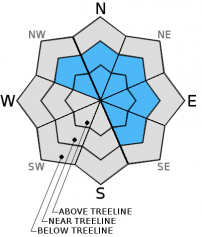
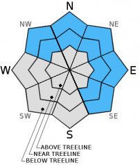
On slopes steeper than 32 degrees, CONSIDERABLE avalanche danger still persists on NW-N-NE-E-SE aspects in near and above treeline terrain due to a combination of wind slabs and persistent slabs. Even though the window for natural avalanches may have passed, human triggered avalanches remain likely. Unusual avalanche conditions exist. Avalanches on steeper slopes could be remotely triggered by a person standing in lower angle terrain. Careful snowpack evaluation, cautious route finding and conservative decision making are essential.

3. Considerable

?

Above Treeline
Dangerous avalanche conditions. Careful snowpack evaluation, cautious route-finding and conservative decision-making essential.

3. Considerable

?

Near Treeline
Dangerous avalanche conditions. Careful snowpack evaluation, cautious route-finding and conservative decision-making essential.

2. Moderate

?

Below Treeline
Heightened avalanche conditions on specific terrain features. Evaluate snow and terrain carefully; identify features of concern.
    Dangerous avalanche conditions. Careful snowpack evaluation, cautious route-finding and conservative decision-making essential.
Avalanche Problem 1: Wind Slab
  • Type ?
  • Aspect/Elevation ?
  • Likelihood ?
    Certain
    Very Likely
    Likely
    Possible
    Unlikely
  • Size ?
    Historic
    Very Large
    Large
    Small

Several human triggered and natural wind slab avalanches occurred yesterday morning. Additional snow since then and winds that have remained strong will mean that fragile wind slabs will remain widespread on wind loaded slopes today. Some of these wind slabs have accumulated above buried surface hoar making remote triggering and extensive propagation of some wind slabs a possibility. Human triggering of wind slabs large enough to bury a person will remain likely today especially in areas where the wind slabs rest above a buried surface hoar layer. Wind loaded near treeline NW-N-NE-E aspects represent the best places to find wind slabs on top of surface hoar, but this combination of wind slabs and surface hoar could also exist on isolated slopes below treeline or even in a few above treeline areas as well. Even in places where wind slabs did not accumulate above surface hoar, human triggered wind slab avalanches could still occur today. Any wind loaded N-NE-E aspect or cross loaded NW or SE aspect in near and above treeline could hold human trigger-able wind slabs

Avalanche Problem 2: Persistent Slab
  • Type ?
  • Aspect/Elevation ?
  • Likelihood ?
    Certain
    Very Likely
    Likely
    Possible
    Unlikely
  • Size ?
    Historic
    Very Large
    Large
    Small

Persistent slabs will remain a problem today due to the weak surface hoar layers buried in the snowpack on some slopes. Slopes where the wind slabs mentioned above have formed above this fragile persistent weak layer will pose the greatest threat to backcountry travelers, but smaller, shallower persistent slabs could still exist in non wind affected areas in near and below treeline terrain as well. Avalanches that fail on buried surface hoar can propagate long distances connecting trees or rocks, and they can wrap around corners. People can also trigger failures in the surface hoar layer on lower angle terrain that propagate into steeper avalanche terrain and cause avalanches. Most of the persistent slabs avalanches that result from the failure of a surface hoar layer in non wind loaded terrain today should remain relatively shallow, but deeper avalanches that fail on a more deeply buried surface hoar layer remain possible on isolated slopes. 

Buried surface hoar does not exist on every slope so this avalanche problem will not exist on all slopes. Unfortunately, determining which slopes the buried surface hoar does exist on is difficult. Recent avalanche activity, shooting cracks, collapsing, whumfing, and snowpit tests can provide some clues, but sometimes the first clue is an avalanche triggered by the party on the slope. So far observations have shown buried surface hoar layers on N-NE-E aspects and a few NW and SE aspects.

recent observations

Yesterday wind slabs that formed above buried surface hoar layers in near treeline and some above treeline terrain failed naturally near Bard's Bowl in Bear Valley and were remotely triggered by skiers standing in lower angle terrain well away from the slopes on Andesite Ridge on Donner Summit and in the Bard's Bowl area. The slides that resulted from the surface hoar failure propagated long distances along that layer. They measured 1-2 ft in depth. In below treeline, non wind affected areas in both of these zones, snowpit tests indicated instability due to the buried surface hoar layers, but no additional avalanches occurred. Snowpit tests near Tinker's Knob along the Sierra Crest between Squaw and Sugarbowl also found the buried surface hoar and yielded unstable results on it. On Becker Ridge near Echo Summit, some minor skier triggered cracking occurred, but observations did not reveal any signs of a buried surface hoar layer

Weather and CURRENT CONDITIONS
weather summary

4 to 12 inches of new snow fell above 7000 ft. in the last 24 hours. Most of this snow fell yesterday. Areas north of Emerald Bay along the Sierra Crest received the most snow with areas north and east of the lake coming in second. Areas south of Emerald Bay received the lower snowfall amounts. Another winter storm will bring more snow and wind to the region tonight. The southwest winds and cloud cover should start increasing this afternoon ahead of this storm. The forecast calls for the southwest winds to increase to gale force with gusts to 115 mph during the night which coincides with the expected timing of snowfall. Snow may start this afternoon and evening, but most of the snow should accumulate during the night. The forecast calls for another 5 to 10 inches between 7000 and 8000 ft and 6 to 12 inches above 8000 ft. This storm should depart the region tomorrow giving us a small break in the weather before another system reaches the area on Friday night and Saturday.


CONDITIONS ALONG THE SIERRA CREST BETWEEN 8200 FT. AND 9200 FT. IN THE LAST 24 HOURS
6am temperature: 17 to 23 deg. F.
Max. temperature: 29 to 34 deg. F.
Average ridgetop wind direction: Southwest
Average ridgetop wind speed: Until midnight: 40 to 50 mph | Since Midnight: 15 to 30 mph
Maximum ridgetop wind gust: 107 mph
New snowfall: 4 to 12 inches
Total snow depth: 48 to 69 inches
Two-Day Mountain Weather Forecast Produced in partnership with the Reno NWS
For 7000 ft. to 8000 ft.
Thursday Thursday Night Friday
Weather: Mostly cloudy in the morning with clouds increasing in the afternoon. Chance of snow in the afternoon Cloudy with snow likely in the evening and snow increasing after midnight Cloudy with a chance of snow showers in the morning. Clouds decreasing in the afternoon
Temperatures: 28 to 35 deg. F. 22 to 29 deg. F. 28 to 35 deg. F.
Mid Slope Winds: Southwest Southwest Southwest
Wind Speed: 20 to 25 mph with gusts to 40 mph increasing to 30 to 35 mph with gusts to 55 mph 40 to 50 mph with gusts to 75 mph increasing to 85 mph after midnight 25 to 35 mph with gusts to 55 mph decreasing to 40 mph in the afternoon
Expected snowfall: trace to 0 5 to 10 up to 1
For 8000 ft. to 9000 ft.
Thursday Thursday Night Friday
Weather: Mostly cloudy in the morning with clouds increasing in the afternoon. Chance of snow in the afternoon Cloudy with snow likely in the evening and snow increasing after midnight Cloudy with a chance of snow showers in the morning. Clouds decreasing in the afternoon
Temperatures: 26 to 33 deg. F. 20 to 27 deg. F. 26 to 33 deg. F.
Ridge Top Winds: West shifting to southwest Southwest West
Wind Speed: 30 to 35 mph with gusts to 55 mph increasing to 50 to 55 mph with gusts to 80 mph in the afternoon 65 to 75 mph with gusts to 115 mph 50 to 55 mph with gusts to 85 mph decreasing to 35 to 40 mph with gusts to 60 mph in the afternoon
Expected snowfall: trace to 0 6 to 12 up to 1
Disclaimer

This avalanche advisory is provided through a partnership between the Tahoe National Forest and the Sierra Avalanche Center. This advisory covers the Central Sierra Nevada Mountains between Yuba Pass on the north and Ebbetts Pass on the south. Click here for a map of the forecast area. This advisory applies only to backcountry areas outside established ski area boundaries. This advisory describes general avalanche conditions and local variations always occur. This advisory expires 24 hours after the posted time unless otherwise noted. The information in this advisory is provided by the USDA Forest Service who is solely responsible for its content.