THIS AVALANCHE FORECAST EXPIRED ON January 17, 2016 @ 7:11 am
Avalanche Forecast published on January 16, 2016 @ 7:11 am
Issued by Andy Anderson - Tahoe National Forest - Sierra Avalanche Center

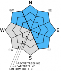
On slopes steeper than 32 degrees, MODERATE avalanche danger exists on NW-N-NE-E-SE aspects at all elevations due to lingering persistent slabs and wind slabs sitting on persistent weak layers. Large human triggered avalanches remain possible today. Unusual avalanche conditions exist. Avalanches on steeper slopes could be remotely triggered by a person standing in lower angle terrain or may be triggered in places traditionally considered safe. Evaluate snow and terrain carefully; identify features of concern.

2. Moderate

?

Above Treeline
Heightened avalanche conditions on specific terrain features. Evaluate snow and terrain carefully; identify features of concern.

2. Moderate

?

Near Treeline
Heightened avalanche conditions on specific terrain features. Evaluate snow and terrain carefully; identify features of concern.

2. Moderate

?

Below Treeline
Heightened avalanche conditions on specific terrain features. Evaluate snow and terrain carefully; identify features of concern.
    Heightened avalanche conditions on specific terrain features. Evaluate snow and terrain carefully; identify features of concern.
Avalanche Problem 1: Persistent Slab
  • Type ?
  • Aspect/Elevation ?
  • Likelihood ?
    Certain
    Very Likely
    Likely
    Possible
    Unlikely
  • Size ?
    Historic
    Very Large
    Large
    Small

1 to 3 layers of buried surface hoar still lurk within the snowpack. Several avalanches have occurred on these buried surface hoar layers with 2 more possibly occurring yesterday. People should not be surprised if they trigger persistent slab avalanches that fail due to one of these surface hoar layers collapsing today. Human triggered persistent slab avalanches large enough to bury people are still possible on any slope steep enough to slide at all elevations where buried surface hoar exists. Avalanches that fail on buried surface hoar can propagate long distances connecting trees or rocks, they can wrap around corners, and they can occur in places traditionally considered safe. People can also trigger failures in the surface hoar layer on lower angle terrain and that failure can propagate into steeper avalanche terrain and cause avalanches. In near and above treeline terrain wind slabs that have formed on top of buried surface hoar layers will behave like large persistent slabs and may look like wind slabs on the surface. In near and below treeline terrain persistent slabs will also exist, but they will be harder to identify. 

Buried surface hoar does not exist on every slope so this avalanche problem will not exist on all slopes. Unfortunately, determining which slopes the buried surface hoar does exist on is difficult. Recent avalanche activity, shooting cracks, collapsing, whumpfing, and snowpit tests can provide some clues, but sometimes the first clue is an avalanche triggered by the party on the slope. So far observations have shown buried surface hoar layers on open N-NE-E aspects and a few NW and SE aspects.

On some slopes where rain falls on the snowpack, the rain on snow could trigger some instabilities like loose wet avalanches or even the persistent slabs. Since the snow level should stay below 7500 to 7000 ft and not much rain is expected, this issue should not become widespread. If more rain falls than forecasted or snow levels climb higher than forecasted, rain triggered persistent slabs could be more of an issue. 


recent observations

Yesterday observations, snowpit data, and test slopes from Hidden Peak and Crystal Bay found some storm snow weaknesses in the recent snow but did not reveal buried surface hoar layers. Some minor cracking and small wind loaded test slope failures occurred as a result of this weakness on Hidden Peak. Evidence suggested that the recent snow was gaining strength on Hidden Peak. On Luther Pass a low elevation snowpit found one of the surface hoar layers but snowpit tests did not show as much lingering weakness associated with it in that spot. On the other hand, we did receive two vague reports of avalanche activity. One was reported as a remotely triggered avalanche on a NE aspect somewhere on Donner Summit which sounds similar to other avalanches that have resulted from failure of the buried surface hoar. The other was reported on a E-SE aspect of Ralston Peak. We don't have any other details about those two.

If you would like to report observations to the avalanche center to help us create better forecasts and help get more information out to more people, please use our submit observation forms:

Weather and CURRENT CONDITIONS
weather summary

Temperatures have warmed up since yesterday as some warm air moved into the region. Cloud cover and southwest winds also increased overnight, and some light snow started early this morning. Since 4 am 1 to 3 inches of new snow has accumulated above 7000 ft. snow. The forecast calls for snow levels to hover around 7000 to 7500 ft today, so areas below that may get light rain instead of snow. Some remote sensors indicate that snow level could rise to 8000 ft. By this afternoon this storm should wind down and depart the region. Winds and cloud cover should decrease overnight before they begin increasing again tomorrow ahead of stronger winter storm. Some precipitation could start as early as tomorrow afternoon but the bulk of this storm should arrive Sunday night and Monday. For more details check in with the Reno NWS.

CONDITIONS ALONG THE SIERRA CREST BETWEEN 8200 FT. AND 9200 FT. IN THE LAST 24 HOURS
6am temperature: 24 to 34 deg. F.
Max. temperature: 25 to 35 deg. F.
Average ridgetop wind direction: Southwest
Average ridgetop wind speed: Until midnight: 5 to 15 mph | After midnight: 20 to 40 mph
Maximum ridgetop wind gust: 89 mph
New snowfall: since 4 am: 1 to 3 inches
Total snow depth: 54 to 78 inches
Two-Day Mountain Weather Forecast Produced in partnership with the Reno NWS
For 7000 ft. to 8000 ft.
Saturday Saturday Night Sunday
Weather: Cloudy with snow showers Mostly cloudy Cloudy with a slight chance of snow in the morning and better chances of snow in the afternoon
Temperatures: 34 to 39 deg. F. 23 to 27 deg. F. 33 to 38 deg. F.
Mid Slope Winds: Southwest Southwest Southwest
Wind Speed: 30 to 40 mph with gusts to 60 mph 20 to 35 mph with gusts to 50 mph decreasing to 15 to 25 mph with gusts to 40 mph after midnight 15 to 25 mph with gusts to 40 mph increasing to 30 to 45 mph with gusts to 65 mph in the afternoon
Expected snowfall: 1 to 4 0 up to 3
For 8000 ft. to 9000 ft.
Saturday Saturday Night Sunday
Weather: Cloudy with snow showers Mostly cloudy Cloudy with a slight chance of snow in the morning and better chances of snow in the afternoon
Temperatures: 29 to 34 deg. F. 22 to 27 deg. F. 29 to 34 deg. F.
Ridge Top Winds: Southwest Southwest Southwest
Wind Speed: 40 to 60 mph with gusts to 90 mph 55 to 60 mph with gusts to 85 mph decreasing to 40 to 45 mph with gusts to 65 mph after midnight 35 to 40 mph with gusts to 60 mph increasing to 55 to 60 mph with gusts to 90 mph in the afternoon
Expected snowfall: 1 to 4 0 up to 3
Disclaimer

This avalanche advisory is provided through a partnership between the Tahoe National Forest and the Sierra Avalanche Center. This advisory covers the Central Sierra Nevada Mountains between Yuba Pass on the north and Ebbetts Pass on the south. Click here for a map of the forecast area. This advisory applies only to backcountry areas outside established ski area boundaries. This advisory describes general avalanche conditions and local variations always occur. This advisory expires 24 hours after the posted time unless otherwise noted. The information in this advisory is provided by the USDA Forest Service who is solely responsible for its content.