

The last avalanche forecast for the 2023-2024 season will post on April 21st. Thank you to all who contributed to the avalanche center this season through observations, volunteer time, and/or financial contributions.
In partnership with: 
The last avalanche forecast for the 2023-2024 season will post on April 21st. Thank you to all who contributed to the avalanche center this season through observations, volunteer time, and/or financial contributions.
| Date and time of observation or avalanche occurrence | Location | Media | Observation made by |
|---|---|---|---|
|
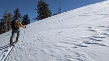
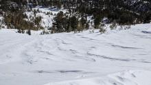
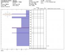
03/02/2021 - 12:20 Snowpack Observation |
Incline Peak Mount Rose Area |
     |
Forecaster |
|
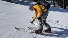
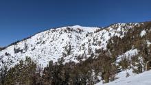
03/01/2021 - 12:00 Snowpack Observation |
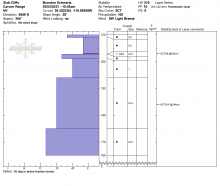
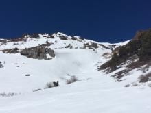
Red Lake Peak Carson Pass Area |
  |
Forecaster |
|
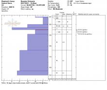
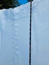
02/28/2021 - 16:20 Snowpack Observation |
Elephant’s Hump Carson Pass Area |
  |
Public |
|
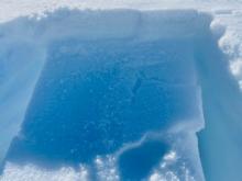
02/28/2021 - 14:26 Snowpack Observation |
Lola Little Truckee Summit Areas |
Public | |
|
02/28/2021 - 13:30 Snowpack Observation |
White Rock Little Truckee Summit Areas |
 |
Public |
|
02/28/2021 - 12:00 Snowpack Observation |
Echo Ridge Echo Summit Area |
Public | |
|
02/28/2021 - 11:00 Snowpack Observation |
Lincoln Ridge Yuba Pass Area |
   |
Forecaster |
|
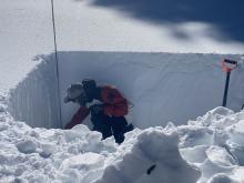
02/27/2021 - 22:45 Snowpack Observation |
Elephant's Hump Carson Pass Area |
    |
Forecaster |
|
02/27/2021 - 12:00 Snowpack Observation |
Lola’s area Little Truckee Summit Areas |
  |
Public |
|
02/26/2021 - 13:01 Snowpack Observation |
Chickadee Ridge / Ophir Peak Mount Rose Area |
  |
Public |
|
02/26/2021 - 12:00 Snowpack Observation |
Greater Bronco Area Mount Rose Area |
Public | |
|
02/26/2021 - 11:30 Snowpack Observation |
Relay Peak Mount Rose Area |
    |
Forecaster |
|
02/26/2021 - 08:11 Snowpack Observation |
Stevens Peak Carson Pass Area |
Public | |
|
02/25/2021 - 13:30 Snowpack Observation |
Castle Valley Donner Summit Area |
   |
Educator NORTH AMERICAN SKI TRAINING AND CLIMBI |
|
02/25/2021 - 12:19 Snowpack Observation |
Deep Creek Ridge Cabin Creek, Deep Creek, or Pole Creek Area |
 |
Guide Tahoe Mountain Scho |


This website is owned and maintained by the non-profit arm of the Sierra Avalanche Center. Some of the content is updated by the USDA avalanche forecasters including the forecasts and some observational data. The USDA is not responsible for any advertising, fund-raising events/information, or sponsorship information, or other content not related to the forecasts and the data pertaining to the forecasts.